Sistema de caverna
Hranice Abyss
Research group figures: dry shaft 69.5 m, flooded part 450.6 m (2022), total 521.1 m; bottom not reached. Older figures still shown on the same site: 473.5 m total and 404 m water depth (ROV, 2016). Deepest point reached by a diver: 265 m (2015).
The world's deepest known flooded abyss: a 69.5 m dry shaft above a lake whose water depth was measured at 450.6 m in 2022 without reaching the bottom. It lies in a national nature reserve, and diving is done only by an accredited research team.
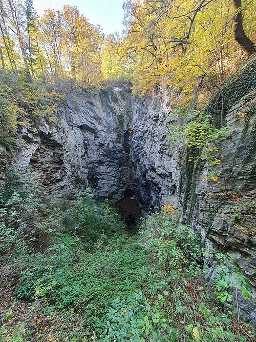
Hranice Abyss (Hranická propast) lies in the Hůrka u Hranic National Nature Reserve on the right bank of the Bečva river, in the small Hranice karst between Hranice, Teplice nad Bečvou and Černotín. From the rim a dry entrance shaft about 104 m long, 34 m wide and 69.5 m deep ends at a small green lake, which is only the apparent floor: beneath it a flooded chasm continues to more than 450 m water depth.
The abyss was mentioned in writing as early as 1580 and appears on Comenius's 1627 map of Moravia. Diving began in the 1960s, first on air and later with helium mixes and closed-circuit rebreathers. Polish diver Krzysztof Starnawski reached 265 m on 21 August 2015, the deepest point reached by a diver. Remotely operated vehicles (underwater robots) have gone deeper: 404 m in September 2016 and about 450 m in 2022, still without reaching the bottom.
The abyss formed through hydrothermal (hypogenic) karst processes: warm, carbon-dioxide-rich mineral water rising along deep faults dissolved the limestone from below. Its decorations resemble those of the nearby Zbrašov Aragonite Caves across the river, which formed the same way and are a public show cave.
Diving is not a recreational activity here. Research diving is carried out by the cave-diving group ZO 7-02 Hranický kras of the Czech Speleological Society, working under an exemption from the Czech nature protection act together with university scientists. Visitors can view the shaft from a platform reached by marked trails.
Geologia
Devonian and Early Carboniferous limestones (Macocha and Líšeň formations). The research group describes two processes: ordinary karst dissolution by rainwater, and hydrothermal (hypogenic) dissolution by lukewarm carbonated mineral water rising along deep faults between the Bohemian Massif and the Western Carpathians, carrying CO2 and traces of helium from great depth.
Água, fluxo e inundações
The water is described as lukewarm, carbonated mineral water heavily saturated with carbon dioxide; the group gives 22.5 °C for the carbonated spring water of the area. A 2022 biological survey using traps found no amphipods, and the researchers concluded the deep water is unsuitable for life.
Por que isso importa
Deepest known flooded abyss in the world and deepest abyss in Czechia; listed by Guinness World Records as the deepest subterranean body of water (450 m, measured August 2022 by the Czech Speleological Society).
Histórico de levantamento topográfico e exploração
| 1580 | First written mention of the abyss, by Tomáš Jordán of Klausenburg. [2] |
| 1963 | Divers descend to 42 m. [2] |
| 1978-12-22 | The Czech Speleological Society group ZO 7-02 Hranický kras is founded. [1] |
| 2000-12 | Krzysztof Starnawski reaches 181 m. [3] |
| 2012-10-01 | Starnawski reaches 223 m and lowers a probe to 373 m. [3] |
| 2015-08-21 | Starnawski reaches 265 m, the deepest point reached by a diver at the site. [3] |
| 2016-09-27 | A remotely operated vehicle from Gral Marine reaches 404 m water depth. [3] |
| 2022-08 | Water depth measured at about 450 m by the Czech Speleological Society without reaching the bottom. [4] [5] |
Entradas e pontos de mergulho
One entrance: the open dry shaft, with the lake at its foot. Access to the water is for the research team only; the public viewpoint platform overlooks the shaft.
Leituras recomendadas
A short history of underwater cave exploration: dated milestones
Conservation, landowners and responsible access
How underwater caves are surveyed and studied
How underwater caves form: karst, dissolution and drowned passages
Hranice Abyss geophysical study (Journal of Geophysical Research: Earth Surface) ↗
Cada informação desta página, com sua fonte (11)
| Informação | Status | Fonte |
|---|---|---|
| The flooded part is 450.6 m deep (2022) and the total depth including the 69.5 m dry shaft is 521.1 m; the bottom has not been reached.The same site's introductory text still gives the 2016 figures of 473.5 m total and 404 m water depth. Guinness records 450 m measured in August 2022. | Fontes divergem | [5] [4] |
| Krzysztof Starnawski reached 265 m on 21 August 2015, the deepest point reached by a diver at the abyss.Guinness states he first dived the abyss in 2015; the research group documents his dives from 2000. | Verificado | [3] [5] |
| A Gral Marine ROV reached 404 m water depth on 27 September 2016. | Verificado | [3] [4] |
| The abyss lies in the Hůrka u Hranic National Nature Reserve (declared 1952, 37.45 ha), managed by the Nature Conservation Agency's Olomouc office. | Verificado | [5] |
| Research by ZO 7-02 Hranický kras is carried out under an exemption from Act No. 114/1992 Coll.The site does not publish rules for other divers; no public diving access was found. | Verificado | [1] |
| The abyss formed in Devonian and Early Carboniferous limestone through both ordinary and hydrothermal (hypogenic) karst processes driven by rising CO2-rich mineral water. | Verificado | [6] [7] |
| The carbonated spring water of the area measures 22.5 °C; the abyss water is described as lukewarm and heavily saturated with CO2.No direct temperature profile of the abyss was published on the pages opened. | Verificado | [6] [7] |
| In July 2022 traps set to look for amphipods caught none, and researchers concluded the water is not suitable for life. | Verificado | [1] |
| Guinness World Records lists Hranice Abyss as the deepest subterranean body of water at 450 m, measured in August 2022 by the Czech Speleological Society. | Verificado | [4] |
| The dry shaft is about 104 m long, 34 m wide and 69.5 m deep. | Verificado | [5] [7] |
| Research, including diving, is done by ZO 7-02 Hranický kras under an exemption from Act No. 114/1992 Coll.; no rules for other divers are published. | Verificado | [1] |
Verificado: declarado por uma fonte oficial ou primária que consultamos. Relatado: proveniente apenas de uma fonte secundária. Fontes divergem: a nota apresenta as duas versões. Pode estar desatualizado: a fonte mais recente que encontramos é antiga.
Escrito com nossas próprias palavras a partir das fontes acima. Reportar uma correção