Découvrez où plonger, quand partir et ce que vous pourriez voir.

Découvrez où plonger, quand partir et ce que vous pourriez voir.
★
Menu
Destinations Sites de plongée Vie marine Épaves Actualités
Planifier un voyage Planificateur de séjour Quand plonger Calculateur de coût Comparaisons Calendrier de la faune marine Température de l'eau Liveaboards Opérateurs & resorts Parcs marins Caissons hyperbares Carte du monde
Plongée souterraine Toute la plongée souterraine Destinations et sites de plongée Systèmes de grottes et cartes Formation et qualifications Centres de plongée et guides Équipement et technologie Sécurité et recherche sur les incidents Sciences, histoire et conservation Ressources et mises à jour
Régions Australie, Nouvelle-Zélande & Asie de l'EstCaraïbes & Atlantique occidentalEurope, Atlantique & MéditerranéeOcéan Indien & Afrique de l'EstÎles du Pacifique & MicronésieMer Rouge & Moyen-OrientAsie du Sud-Est et Triangle de CorailLes Amériques et Pacifique Est Pays
Apprendre & Outils Tous les guides Certifications Guides d'équipement Vidéos Interroger les données Agents IA API
À propos À propos de nous Méthodologie Avertissement Contact
Votre vue
★ Enregistré

Vos destinations, sites et espèces favoris, enregistrés dans ce navigateur.

API GATEWAY

Accès JSON gratuit en lecture seule aux données en cache de l'atlas.

Mode sombre

Vue Guidée
Nouveau en plongée ? Profondeurs, courants, niveaux de certification ? Nous expliquons chaque terme au fil de votre navigation, en langage clair. Les mêmes données, avec l'aide intégrée.

Vue Expert
Vous connaissez déjà la différence entre un tombant et un drift dive. Juste les données : claires, rapides et compactes. C'est la vue par défaut.

Langue de l'interface
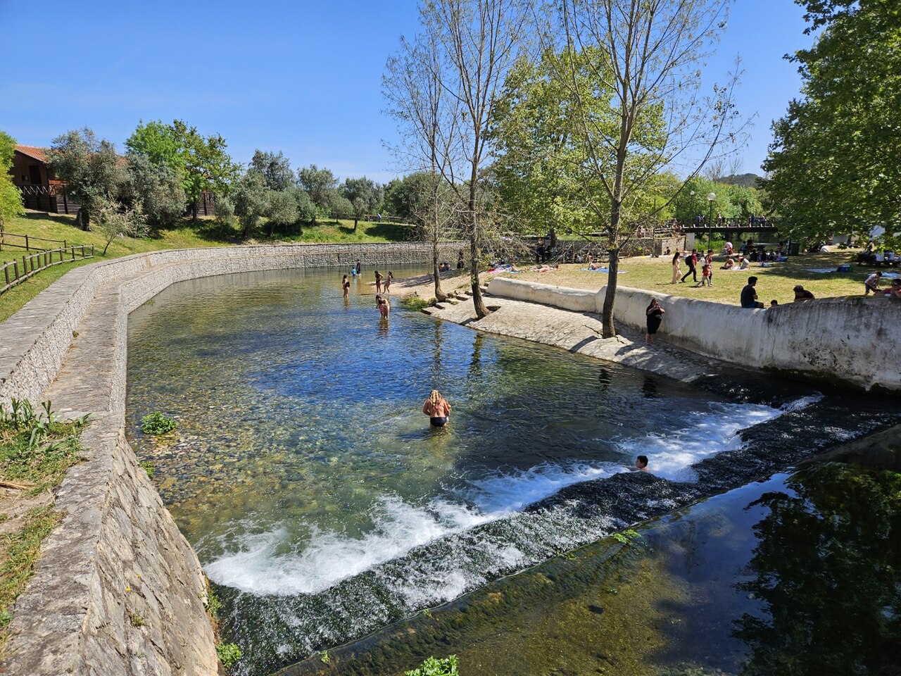
Olhos de Água do Alviela

Olhos de Água do Alviela

Photo: GualdimG · CC BY-SA 4.0
Statut d'accès non vérifié · tel que publié 2002 The expedition's Portuguese partners obtained the necessary authorisations; no current public access rule for diving was found. Les règles d'accès changent : confirmez auprès du propriétaire ou de l'autorité gestionnaire avant de partir.
Documenté Aussi connu sous le nom de: Alviela spring, Nascente do Alviela, Olhos d'Água do Alviela, Alviela
Longueur explorée
Non publié
Profondeur documentée
125 m (410 ft)
Entrées répertoriées
0
Température de l'eau
17 °C
Levés et exploration
FFESSM Commission nationale de plongée souterraine (CNPS), Portuguese cavers (Filipe Worsdell, Olímpio Martins, Piotr Gajek, José António Crispim)

1,370 m surveyed during the CNPS-FFESSM expedition; total cave length not stated. Reached during the CNPS-FFESSM expedition, more than 700 m from the entrance.

The main karst spring of the river Alviela at the foot of the Monsanto syncline in central Portugal, once tapped for Lisbon's water supply. A French-Portuguese expedition surveyed 1,370 m and reached 125 m depth.

The Olhos de Água do Alviela rise at the foot of the Monsanto syncline and drain most of the Planalto de Santo António karst plateau, with part of the water thought to come from the Mira-Minde polje to the north-east. In the early twentieth century the spring was captured and linked by aqueduct to Lisbon, though it was later replaced by other sources.

The flooded cave descends as a sizeable gallery, 4 to 8 m across in places, with side branches. Patrick Jolivet reached about 580 m and 98 m depth in 1988. A national cave-diving commission (CNPS) expedition of the FFESSM, organised with Portuguese cavers who handled accommodation, re-lining and authorisations, re-equipped the line, surveyed 1,370 m including about 200 m of new passage, and stopped at 125 m depth more than 700 m from the entrance.

The account notes a water temperature of about 17 °C and a depigmented crayfish seen 140 m into a side passage.

Eau, courant et crues

The spring drains the Planalto de Santo António; tracing work cited by the expedition indicates that part of the water comes from the Mira-Minde polje.

Pourquoi c'est important

A major Portuguese karst spring, historically part of Lisbon's water supply, and the deepest documented cave dive in the sources found for Portugal.

Conditions

Visibility on some dives in side passages dropped to 0.5-1.5 m on the return.

Fourchettes indicatives issues de sources publiées, pas les conditions actuelles.

Historique du relevé topographique et de l'exploration

1988Patrick Jolivet reaches about 580 m from the entrance at -98 m. [1]
2002A CNPS-FFESSM expedition with Portuguese cavers re-lines and surveys 1,370 m and reaches -125 m. [1]

Entrées et sites de plongée

One entrance, the spring pool; the expedition rigged a tyrolean to move equipment to the pool edge and a rope deviation for the last pitch.

Aucune entrée individuelle n'est encore répertoriée pour ce système.

Sources: [1] plongeesout.ffspeleo.fr ↗[2] plongeesout.ffspeleo.fr ↗ · vérifié 2026-10-14
Chaque information de cette page, avec sa source (7)
InformationStatutSource
The expedition's deepest dive stopped at -125 m more than 700 m from the entrance. Vérifié [1]
The expedition produced 1,370 m of survey and about 200 m of new passage with a maximum depth of -125 m. Vérifié [1]
Patrick Jolivet's 1988 terminus was at about 580 m and -98 m. Vérifié [1]
The expedition is filed on the FFS site as the 2002 FFESSM account; the text says the CNPS adopted the project in September 2002.Exact expedition dates are not stated in the account. Signalé [1]
The account mentions water at about 17 °C. Vérifié [1]
The spring drains most of the Planalto de Santo António, with part of the water coming from the Mira-Minde polje; it was captured for Lisbon's water supply by an aqueduct built early in the twentieth century. Vérifié [1]
Portuguese partners handled accommodation, re-equipping the cave and the authorisations for the expedition. Peut être obsolète [1]

Vérifié : indiqué par une source officielle ou primaire que nous avons consultée. Signalé : issu d'une source secondaire uniquement. Sources contradictoires : la note présente les deux versions. Peut être obsolète : la source la plus récente que nous avons trouvée est ancienne.

Rédigé dans nos propres mots à partir des sources ci-dessus. Signaler une correction

Australie, Nouvelle-Zélande & Asie de l'Est

Cairns & the Ribbon ReefsNingaloo ReefCoral Sea & Osprey ReefOkinawa & the Kerama IslandsPoor Knights IslandsTownsville & the YongalaGreen IslandIzu Peninsula

Caraïbes & Atlantique occidental

BonaireCozumelRiviera Maya & the CenotesBelize Barrier ReefGrand CaymanIsla Mujeres & CancúnRoatánTiger Beach & Grand Bahama

Europe, Atlantique & Méditerranée

Malta & GozoSilfra & IcelandThe AzoresCanary IslandsLarnaca & the ZenobiaScapa FlowArctic NorwayMadeira

Océan Indien & Afrique de l'Est

North & South Malé AtollsAri AtollBaa Atoll & Hanifaru BayAliwal Shoal & UmkomaasMafia IslandMauritiusSeychellesSodwana Bay

Îles du Pacifique & Micronésie

PalauChuuk (Truk) LagoonFakaravaKona, HawaiʻiRangiroaTaveuni & Rainbow ReefBeqa Lagoon & Pacific HarbourEspiritu Santo

Mer Rouge & Moyen-Orient

Sharm El Sheikh & Ras MohammedBrothers, Daedalus & St John'sDahabHurghada & El GounaMarsa Alam & the Deep SouthAqabaDaymaniyat IslandsMusandam Peninsula

Asie du Sud-Est et Triangle de Corail

Bali & Nusa PenidaKomodoRaja AmpatSipadan & MabulAnilaoCoronKoh TaoLembeh Strait

Les Amériques et Pacifique Est

Galápagos IslandsCocos IslandFlorida KeysSea of Cortez & Cabo PulmoSocorro & the RevillagigedosBritish ColumbiaCalifornia Channel IslandsCosta Rica Pacific Coast