Nerede dalış yapacağınızı, ne zaman gideceğinizi ve neler görebileceğinizi keşfedin.

Nerede dalış yapacağınızı, ne zaman gideceğinizi ve neler görebileceğinizi keşfedin.
★
Menü
Destinasyonlar Dalış Noktaları Deniz Yaşamı Batıklar Haberler
Gezi planla Gezi planlayıcı Dalış için en iyi zaman Maliyet hesaplayıcısı Karşılaştırmalar Deniz canlıları takvimi Su sıcaklığı Liveaboard'lar Operatörler & tatil köyleri Deniz parkları Hiperbarik merkezler Dünya haritası
Mağara dalışı Tüm mağara dalışları Destinasyonlar ve Dalış Noktaları Mağara Sistemleri ve Haritalar Eğitim ve Sertifikalar Dalış Merkezleri ve Rehberler Ekipman ve Teknoloji Güvenlik ve Olay Araştırması Bilim, Tarih ve Koruma Kaynaklar ve Güncellemeler
Bölgeler Avustralya, Yeni Zelanda ve Doğu AsyaKarayipler ve Batı AtlantikAvrupa, Atlantik & AkdenizHint Okyanusu ve Doğu AfrikaPasifik Adaları & MikronezyaKızıldeniz & Orta DoğuGüneydoğu Asya & Mercan ÜçgeniAmerika & Doğu Pasifik Ülkeler
Öğren ve Araçlar Tüm rehberler Sertifikasyonlar Ekipman rehberleri Videolar Veriye Sor Yapay Zeka Ajanları API
Hakkında Hakkımızda Metodoloji Sorumluluk Reddi İletişim
Görünümün
★ Kaydedildi

Yıldızladığınız destinasyonlar, dalış noktaları ve türler; bu tarayıcıda saklanır.

API GATEWAY

Atlasın önbelleğe alınmış verilerine ücretsiz salt okunur JSON erişimi.

Karanlık mod

Rehberli Görünüm
Dalışa yeni mi başladınız? Derinlikler, akıntılar, sertifika seviyeleri? Gezinirken her terimi sade bir dille açıklıyoruz. Aynı veriler, yardım dahil.

Uzman Görünümü
Duvar dalışı ile drift dive arasındaki farkı zaten biliyorsunuz. Sadece veriler: sade, hızlı ve kompakt. Bu varsayılan görünümdür.

Arayüz dili
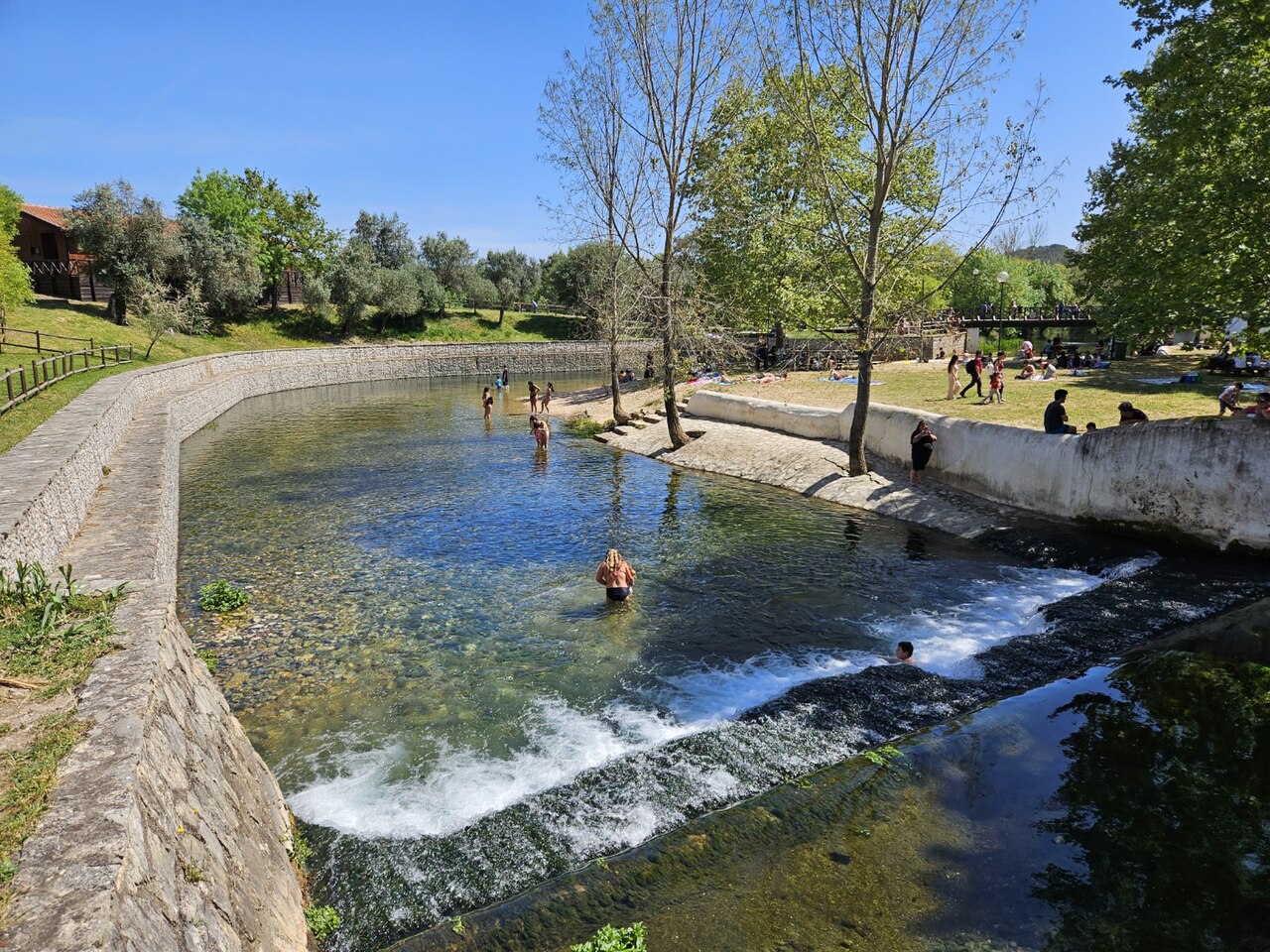
Olhos de Água do Alviela

Olhos de Água do Alviela

Yeniden çıkış noktası125 m derinPortugal, Central Portugal (Planalto de Santo António)
Fotoğraf: GualdimG · CC BY-SA 4.0
Erişim durumu doğrulanmadı · yayımlandığı şekliyle 2002 The expedition's Portuguese partners obtained the necessary authorisations; no current public access rule for diving was found. Erişim kuralları değişebilir: seyahat etmeden önce arazi sahibi veya yönetim makamıyla teyit edin.
Belgelenmiş Aynı zamanda bilinen adıyla: Alviela spring, Nascente do Alviela, Olhos d'Água do Alviela, Alviela
Surveylenen uzunluk
Yayımlanmamış
Belgelenmiş derinlik
125 m (410 ft)
Listelenen girişler
0
Su sıcaklığı
17 °C
Haritalam ve keşif
FFESSM Commission nationale de plongée souterraine (CNPS), Portuguese cavers (Filipe Worsdell, Olímpio Martins, Piotr Gajek, José António Crispim)

1,370 m surveyed during the CNPS-FFESSM expedition; total cave length not stated. Reached during the CNPS-FFESSM expedition, more than 700 m from the entrance.

The main karst spring of the river Alviela at the foot of the Monsanto syncline in central Portugal, once tapped for Lisbon's water supply. A French-Portuguese expedition surveyed 1,370 m and reached 125 m depth.

The Olhos de Água do Alviela rise at the foot of the Monsanto syncline and drain most of the Planalto de Santo António karst plateau, with part of the water thought to come from the Mira-Minde polje to the north-east. In the early twentieth century the spring was captured and linked by aqueduct to Lisbon, though it was later replaced by other sources.

The flooded cave descends as a sizeable gallery, 4 to 8 m across in places, with side branches. Patrick Jolivet reached about 580 m and 98 m depth in 1988. A national cave-diving commission (CNPS) expedition of the FFESSM, organised with Portuguese cavers who handled accommodation, re-lining and authorisations, re-equipped the line, surveyed 1,370 m including about 200 m of new passage, and stopped at 125 m depth more than 700 m from the entrance.

The account notes a water temperature of about 17 °C and a depigmented crayfish seen 140 m into a side passage.

Su, akıntı ve taşkın

The spring drains the Planalto de Santo António; tracing work cited by the expedition indicates that part of the water comes from the Mira-Minde polje.

Neden önemlidir

A major Portuguese karst spring, historically part of Lisbon's water supply, and the deepest documented cave dive in the sources found for Portugal.

Koşullar

Visibility on some dives in side passages dropped to 0.5-1.5 m on the return.

Yayımlanmış kaynaklardan alınan tipik aralıklar, anlık koşulları yansıtmaz.

Survey ve keşif tarihi

1988Patrick Jolivet reaches about 580 m from the entrance at -98 m. [1]
2002A CNPS-FFESSM expedition with Portuguese cavers re-lines and surveys 1,370 m and reaches -125 m. [1]

Girişler ve dalış noktaları

One entrance, the spring pool; the expedition rigged a tyrolean to move equipment to the pool edge and a rope deviation for the last pitch.

Bu sistem için henüz bireysel giriş noktası listelenmemiş.

Kaynaklar: [1] plongeesout.ffspeleo.fr ↗[2] plongeesout.ffspeleo.fr ↗ · kontrol edildi 2026-10-14
Bu sayfadaki her bilgi, kaynağıyla birlikte (7)
BilgiDurumKaynak
The expedition's deepest dive stopped at -125 m more than 700 m from the entrance. Doğrulandı [1]
The expedition produced 1,370 m of survey and about 200 m of new passage with a maximum depth of -125 m. Doğrulandı [1]
Patrick Jolivet's 1988 terminus was at about 580 m and -98 m. Doğrulandı [1]
The expedition is filed on the FFS site as the 2002 FFESSM account; the text says the CNPS adopted the project in September 2002.Exact expedition dates are not stated in the account. Bildirildi [1]
The account mentions water at about 17 °C. Doğrulandı [1]
The spring drains most of the Planalto de Santo António, with part of the water coming from the Mira-Minde polje; it was captured for Lisbon's water supply by an aqueduct built early in the twentieth century. Doğrulandı [1]
Portuguese partners handled accommodation, re-equipping the cave and the authorisations for the expedition. Güncel olmayabilir [1]

Doğrulandı: incelediğimiz resmi veya birincil bir kaynak tarafından belirtilmiştir. Raporlandı: yalnızca ikincil bir kaynaktan. Kaynaklar çelişiyor: notta her iki versiyon da verilmiştir. Güncel olmayabilir: bulduğumuz en yeni kaynak eskidir.

Yukarıdaki kaynaklardan kendi ifadelerimizle yazıldı. Düzeltme bildir

Avustralya, Yeni Zelanda ve Doğu Asya

Cairns & the Ribbon ReefsNingaloo ReefCoral Sea & Osprey ReefOkinawa & the Kerama IslandsPoor Knights IslandsTownsville & the YongalaGreen IslandIzu Peninsula

Karayipler ve Batı Atlantik

BonaireCozumelRiviera Maya & the CenotesBelize Barrier ReefGrand CaymanIsla Mujeres & CancúnRoatánTiger Beach & Grand Bahama

Avrupa, Atlantik & Akdeniz

Malta & GozoSilfra & IcelandThe AzoresCanary IslandsLarnaca & the ZenobiaScapa FlowArctic NorwayMadeira

Hint Okyanusu ve Doğu Afrika

North & South Malé AtollsAri AtollBaa Atoll & Hanifaru BayAliwal Shoal & UmkomaasMafia IslandMauritiusSeychellesSodwana Bay

Pasifik Adaları & Mikronezya

PalauChuuk (Truk) LagoonFakaravaKona, HawaiʻiRangiroaTaveuni & Rainbow ReefBeqa Lagoon & Pacific HarbourEspiritu Santo

Kızıldeniz & Orta Doğu

Sharm El Sheikh & Ras MohammedBrothers, Daedalus & St John'sDahabHurghada & El GounaMarsa Alam & the Deep SouthAqabaDaymaniyat IslandsMusandam Peninsula

Güneydoğu Asya & Mercan Üçgeni

Bali & Nusa PenidaKomodoRaja AmpatSipadan & MabulAnilaoCoronKoh TaoLembeh Strait

Amerika & Doğu Pasifik

Galápagos IslandsCocos IslandFlorida KeysSea of Cortez & Cabo PulmoSocorro & the RevillagigedosBritish ColumbiaCalifornia Channel IslandsCosta Rica Pacific Coast