Sharks
Lemon Shark
Negaprion brevirostris · Cartilaginous fish — family Carcharhinidae
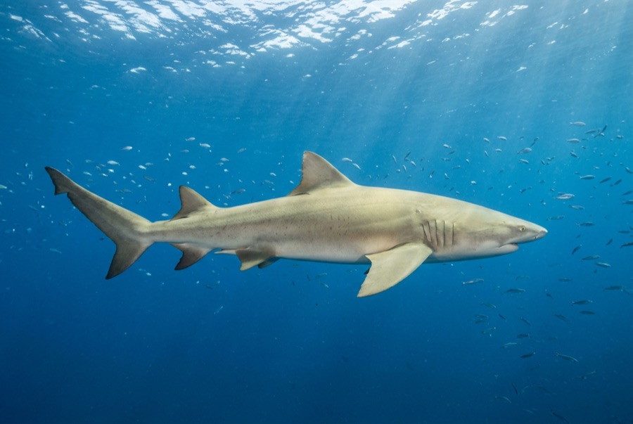
Lemon sharks bring character to the sand flats of the Bahamas — big, blunt-faced animals in olive-gold livery, trailing remoras like streamers, mouths fixed in an underbite that ruins their menace at close range. They are among the best-studied sharks on Earth thanks to decades of work in Bimini's mangroves, which revealed social networks, nursery fidelity, and females returning to their own birth lagoons to pup. At Tiger Beach they play second lead to the tigers, arriving first, staying latest, and stacking on the bottom beneath the boat like parked aircraft.
Onde e quando ver um
"Residente" significa que a maioria dos mergulhos naquele destino os encontra; "sazonal" significa presença confiável nos meses listados; qualquer outra coisa é um bônus, não um plano.
| Destino | Fiabilidade | Meses | Notas |
|---|---|---|---|
| Tiger Beach & Grand BahamaThe Bahamas | Resident — seen on most dives | Nov–Apr | |
| Florida KeysUnited States | Occasional | Todo o ano | |
| Nassau & New ProvidenceThe Bahamas | Occasional | Todo o ano |
Melhor mês, em resumo
| Mês | Destinos fiáveis |
|---|---|
| January | Tiger Beach & Grand Bahama · Florida Keys · Nassau & New Providence |
| February | Tiger Beach & Grand Bahama · Florida Keys · Nassau & New Providence |
| March | Tiger Beach & Grand Bahama · Florida Keys · Nassau & New Providence |
| April | Tiger Beach & Grand Bahama · Florida Keys · Nassau & New Providence |
| May | Florida Keys · Nassau & New Providence |
| June | Florida Keys · Nassau & New Providence |
| July | Florida Keys · Nassau & New Providence |
| August | Florida Keys · Nassau & New Providence |
| September | Florida Keys · Nassau & New Providence |
| October | Florida Keys · Nassau & New Providence |
| November | Tiger Beach & Grand Bahama · Florida Keys · Nassau & New Providence |
| December | Tiger Beach & Grand Bahama · Florida Keys · Nassau & New Providence |
Entendendo-os
Habitat: Shallow sand flats, mangrove nurseries, and reef edges; adults commute between lagoons and deeper ledges
Distribuição: Western Atlantic from the Carolinas and Bahamas to Brazil, with a separate population off West Africa; the closely related sicklefin lemon shark fills the same niche in the Indo-Pacific
Comportamento: A yellow-bronze, twin-dorsaled shark that works low over the bottom, often escorted by remoras. Famously social for a shark — juveniles form groups in mangrove nurseries with measurable personalities, and adults gather seasonally at fixed winter sites. At Tiger Beach they cruise under the boat and rest on sand in numbers.
Dieta: Bony fish and rays taken over sand, plus crustaceans; hunts most actively at dawn and dusk
Tamanho: normalmente cerca de 2.5 m; documentado até 3.4 m (total length).
Como se comportar perto de um
Standard baited-dive discipline: stay settled in the sand line, hands in, let sharks pass overhead without reaching up, and avoid crowding animals resting on the bottom.
Conservação
Vulnerable — coastal development is squeezing the mangrove nurseries the species depends on, and it is fished through much of its Atlantic range outside sanctuary nations.
Pontos mapeados conhecidos por eles
Assista
Dos canais oficiais
Best Places to Dive with Whale Sharks

Outrageously Tiny Fish

Sink or Swim? with Monét X Change | Monterey Bay Aquarium
Os vídeos são links incorporados dos próprios canais dos criadores — não hospedamos nada e creditamos tudo.