Pontos de mergulho, épocas e vida marinha — pesquisados, mapeados, planeados.
Menu
Destinos Pontos de Mergulho Vida Marinha Naufrágios Notícias
Planejar uma viagem Planejador de viagem Quando mergulhar Calculadora de custos Comparações Calendário de vida marinha Temperatura da água Liveaboards Operadores & resorts Parques marinhos Câmaras hiperbáricas Mapa mundial
Regiões Austrália, Nova Zelândia e Ásia OrientalCaribe e Atlântico OcidentalEuropa, Atlântico & MediterrâneoOceano Índico e África OrientalIlhas do Pacífico & MicronésiaMar Vermelho & Médio OrienteSudeste Asiático e Triângulo de CoralAs Américas e o Pacífico Oriental Países
Aprender e Ferramentas Todos os guias Certificações Guias de equipamento Vídeos Consulte os Dados Agentes de IA API
Sobre Sobre nós Metodologia Aviso legal Contato
A sua vista
★ Guardado

Os seus destinos, sítios de mergulho e espécies favoritos — guardados neste browser.

API GATEWAY

Acesso JSON gratuito e só de leitura aos dados em cache do atlas.

Modo escuro

🧭 Vista Guiada
Novo no mergulho — profundidades, correntes, níveis de certificação? Explicamos cada termo enquanto navega, em linguagem simples. Os mesmos dados, com a ajuda integrada.

⚡ Vista de Especialista
Já sabe a diferença entre uma parede e um drift dive. Apenas os dados — claros, rápidos e compactos. Esta é a vista predefinida.

Idioma da interface
SS Benwood — illustrative image

SS Benwood

Norwegian-flagged merchant freighter (ore carrier) Afundado 1942 8–14 m Florida Keys
Ilustração gerada por IA
Houve vidas perdidas aquiThe crew abandoned ship and survived. Os operadores locais pedem que o naufrágio seja mergulhado com o respeito correspondente.
Bem documentado
Profundidade até o convés
8 m / 26 ft
Profundidade máxima
14 m / 46 ft
Construído / afundado
1910 / 1942
Comprimento
110 m
Tonelagem
3,931 GRT
Orientação
Broken And Flattened; Bow Section Most Intact
Nível
Beginner
Melhores meses
Apr–Sep

A história

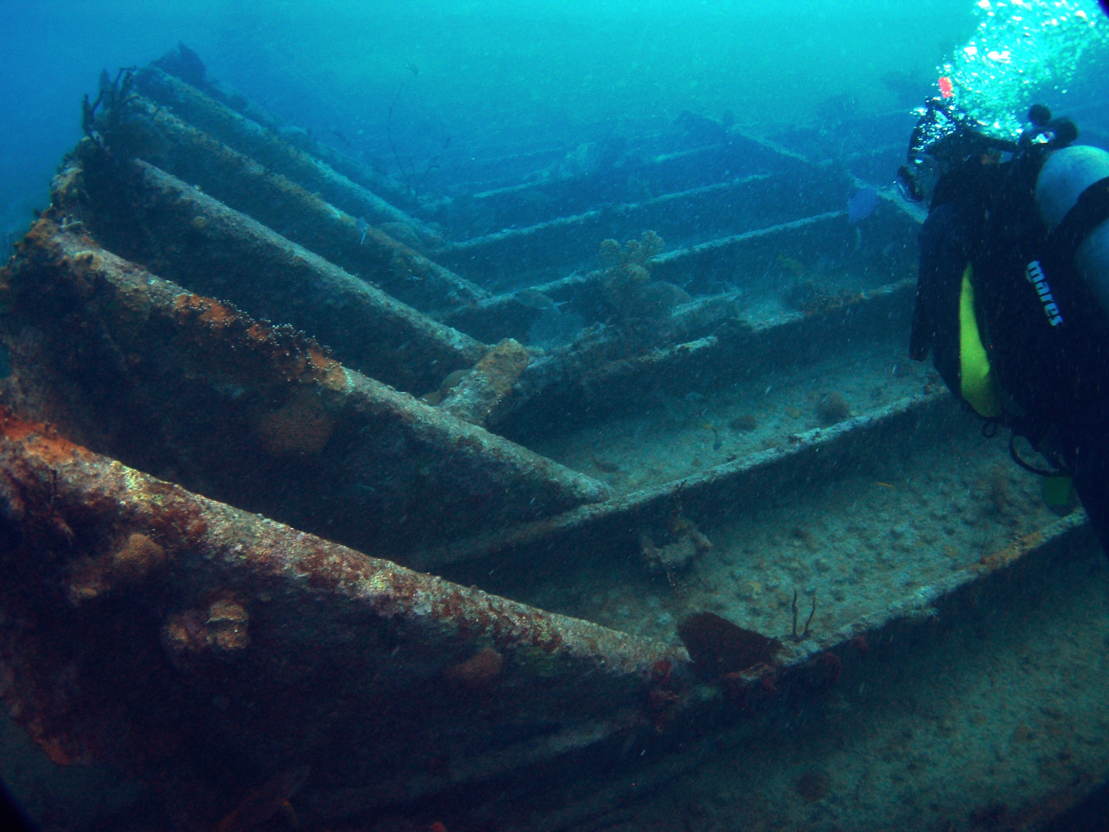
In the spring of 1942 German U-boats were burning ships within sight of Florida's beaches, so merchant vessels ran the coast at night with every light doused. Off Key Largo on 9 April, that precaution produced its own disaster: the ore carrier Benwood and the tanker Robert C. Tuttle, each invisible to the other, met nearly head-on. Her bow crushed, the Benwood's master turned for shoal water and ordered the crew off; the ship settled on the bottom and was declared a total loss. What war began, peace finished — the hulk was dynamited as a hazard to navigation and, by most accounts, later served for target practice — leaving today's wreck a flattened steel skeleton rather than an intact ship. That is exactly why divers love her. Lying between about 8 and 14 meters on the edge of the reef, the bow still rising proud with rows of hull ribs running aft, she is the Keys' classic easy wreck: a second dive, a night dive, a first wreck for new divers, and a dense fish haven after eighty years underwater.

Como afundou: Collision with the tanker Robert C. Tuttle on 9 April 1942, both ships running blacked out against U-boat attack; the damaged Benwood was run toward shallow water and lost.

A mergulhar nela hoje

Condição: Broken low to the seabed, heavily encrusted; bow structure still stands several meters tall

Penetração: None. The wreck is fully open — ribs, plates and machinery with no enclosed spaces left.

Certificação recomendada: Open Water

Corrente: Mild · Visibilidade: 10–25 m

Vida marinha: Clouds of grunt and snapper pack the bow, green morays and spiny lobster hole up in the ribs, nurse sharks doze under plates, and night dives turn up octopus and hunting barracuda.

Perigos: Occasional surge over the shallows and sharp, rusted plating

Proteção & legislação

Within Florida Keys National Marine Sanctuary and part of its Shipwreck Trail — take nothing

Salvage and souvenir hunters stripped her decades ago; what remains is protected sanctuary property.

Assista

Dos canais oficiais

Todos os vídeos →

Os vídeos são links incorporados dos próprios canais dos criadores — não hospedamos nada e creditamos tudo.

Fontes: NOAA ↗ · Factos verificados em relação às fontes acima; os campos sem suporte estão assinalados como não verificado ainda.

Austrália, Nova Zelândia e Ásia Oriental

Cairns & the Ribbon ReefsNingaloo ReefCoral Sea & Osprey ReefOkinawa & the Kerama IslandsPoor Knights IslandsTownsville & the YongalaGreen IslandIzu Peninsula

Caribe e Atlântico Ocidental

BonaireCozumelRiviera Maya & the CenotesBelize Barrier ReefGrand CaymanIsla Mujeres & CancúnRoatánTiger Beach & Grand Bahama

Europa, Atlântico & Mediterrâneo

Malta & GozoSilfra & IcelandThe AzoresCanary IslandsLarnaca & the ZenobiaScapa FlowArctic NorwayMadeira

Oceano Índico e África Oriental

North & South Malé AtollsAri AtollBaa Atoll & Hanifaru BayAliwal Shoal & UmkomaasMafia IslandMauritiusSeychellesSodwana Bay

Ilhas do Pacífico & Micronésia

PalauChuuk (Truk) LagoonFakaravaKona, HawaiʻiRangiroaTaveuni & Rainbow ReefBeqa Lagoon & Pacific HarbourEspiritu Santo

Mar Vermelho & Médio Oriente

Sharm El Sheikh & Ras MohammedBrothers, Daedalus & St John'sDahabHurghada & El GounaMarsa Alam & the Deep SouthAqabaDaymaniyat IslandsMusandam Peninsula

Sudeste Asiático e Triângulo de Coral

Bali & Nusa PenidaKomodoRaja AmpatSipadan & MabulAnilaoCoronKoh TaoLembeh Strait

As Américas e o Pacífico Oriental

Galápagos IslandsCocos IslandFlorida KeysSea of Cortez & Cabo PulmoSocorro & the RevillagigedosBritish ColumbiaCalifornia Channel IslandsCosta Rica Pacific Coast