Siti di immersione, stagioni e fauna marina — ricercati, mappati, pianificati.
Menu
Destinazioni Siti di immersione Vita marina Relitti Notizie
Pianifica un viaggio Pianificatore di viaggi Quando immergersi Calcolatore dei costi Confronti Calendario della fauna marina Temperatura dell'acqua Liveaboard Operatori & resort Parchi marini Camere iperbariche Mappa del mondo
Regioni Australia, Nuova Zelanda e Asia OrientaleCaraibi e Atlantico occidentaleEuropa, Atlantico e MediterraneoOceano Indiano e Africa OrientaleIsole del Pacifico & MicronesiaMar Rosso & Medio OrienteAsia meridionale e Triangolo dei CoralliLe Americhe e il Pacifico orientale Paesi
Impara e strumenti Tutte le guide Brevetti Guide all'attrezzatura Video Interroga i dati AI Agent API
Informazioni Chi siamo Metodologia Disclaimer Contatti
La tua vista
★ Salvato

Le tue destinazioni, siti e specie preferiti — salvati in questo browser.

API GATEWAY

Accesso JSON gratuito in sola lettura ai dati in cache dell'atlante.

Modalità scura

🧭 Visualizzazione Guidata
Sei nuovo alle immersioni — profondità, correnti, livelli di brevetto? Spieghiamo ogni termine mentre navighi, in modo semplice e chiaro. Gli stessi dati, con il supporto integrato.

⚡ Visualizzazione Esperta
Conosci già la differenza tra una parete e una drift dive. Solo i dati — chiari, rapidi e compatti. Questa è la visualizzazione predefinita.

Lingua dell'interfaccia
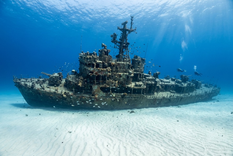
HTMS Sattakut — illustrative image

HTMS Sattakut

Royal Thai Navy patrol vessel (former US Navy landing craft infantry), scuttled as an artificial reef Affondata 2011 18–30 m Koh Tao
Illustrazione generata dall'AI
Qui si sono perse delle viteNone. Gli operatori locali chiedono che il relitto venga visitato con il dovuto rispetto.
Documentato
Profondità al ponte
18 m / 59 ft
Profondità massima
30 m / 98 ft
Costruito / affondato
1944 / 2011
Lunghezza
48 m
Orientamento
Upright
Livello
Intermediate
Mesi migliori
Mar–Sep

La storia

The Sattakut had two careers separated by an ocean. Launched in 1944 as a US Navy landing craft infantry — one of the flat-bottomed troop carriers built by the hundred for the island war — she saw Pacific service before being transferred to the Royal Thai Navy in the late 1940s, which kept her working as a patrol vessel for decades under the name Sattakut. When her service finally ended, the navy donated the hull, and on 18 June 2011 she was cleaned and scuttled a short boat ride from Koh Tao's western shore, near the pinnacle of Hin Pee Wee. She sits upright on the sand, bow gun still mounted and pointing into the green, wheelhouse doorways cut wide for safe swim-throughs. On an island that certifies more new divers than almost anywhere on earth, she has become the standard first wreck: deep enough to matter, small enough to circle twice, and reliably escorted by batfish.

Come è affondata: Decommissioned and deliberately scuttled off Koh Tao on 18 June 2011 as an artificial reef.

Immersioni su di essa oggi

Condizione: Young, tidy, and intact, with sponge and oyster growth accelerating each season.

Penetrazione: Limited. Prepared openings allow supervised passes through the wheelhouse and deck spaces; the lower hull silts and is left to wreck courses. Entrare in qualsiasi ambiente overhead richiede una formazione specifica — come minimo una certificazione wreck, e una formazione tecnica wreck per la penetrazione completa.

Certificazione consigliata: Advanced Open Water

Corrente: Mild · Visibilità: 5–20 m

Vita marina: Batfish escort divers on the line, snapper and fusiliers stream over the gun, porcupinefish loiter in the wheelhouse, and groupers hold the shadow under the stern.

Pericoli: Visibility swings widely with season; multiple training groups can crowd the mooring; mind gas at a site deeper than the island's reefs.

Tutela & normativa

An artificial reef stays complete only if every diver leaves it so.

Guarda

Dai canali ufficiali

Tutti i video →

I video sono link incorporati ai canali dei rispettivi autori — non ospitiamo nulla e diamo sempre credito a tutti.

Fonti: Wikipedia ↗ · Dati verificati rispetto alle fonti indicate; i campi privi di riscontro sono contrassegnati come non ancora verificati.

Australia, Nuova Zelanda e Asia Orientale

Cairns & the Ribbon ReefsNingaloo ReefCoral Sea & Osprey ReefOkinawa & the Kerama IslandsPoor Knights IslandsTownsville & the YongalaGreen IslandIzu Peninsula

Caraibi e Atlantico occidentale

BonaireCozumelRiviera Maya & the CenotesBelize Barrier ReefGrand CaymanIsla Mujeres & CancúnRoatánTiger Beach & Grand Bahama

Europa, Atlantico e Mediterraneo

Malta & GozoSilfra & IcelandThe AzoresCanary IslandsLarnaca & the ZenobiaScapa FlowArctic NorwayMadeira

Oceano Indiano e Africa Orientale

North & South Malé AtollsAri AtollBaa Atoll & Hanifaru BayAliwal Shoal & UmkomaasMafia IslandMauritiusSeychellesSodwana Bay

Isole del Pacifico & Micronesia

PalauChuuk (Truk) LagoonFakaravaKona, HawaiʻiRangiroaTaveuni & Rainbow ReefBeqa Lagoon & Pacific HarbourEspiritu Santo

Mar Rosso & Medio Oriente

Sharm El Sheikh & Ras MohammedBrothers, Daedalus & St John'sDahabHurghada & El GounaMarsa Alam & the Deep SouthAqabaDaymaniyat IslandsMusandam Peninsula

Asia meridionale e Triangolo dei Coralli

Bali & Nusa PenidaKomodoRaja AmpatSipadan & MabulAnilaoCoronKoh TaoLembeh Strait

Le Americhe e il Pacifico orientale

Galápagos IslandsCocos IslandFlorida KeysSea of Cortez & Cabo PulmoSocorro & the RevillagigedosBritish ColumbiaCalifornia Channel IslandsCosta Rica Pacific Coast