Situs selam, musim, dan kehidupan laut — diteliti, dipetakan, direncanakan.
Menu
Destinasi Lokasi Selam Kehidupan Laut Bangkai kapal Berita
Rencanakan perjalanan Perencana trip Kapan waktu terbaik menyelam Kalkulator biaya Perbandingan Kalender kehidupan laut Suhu air Liveaboard Operator & resor Taman laut Ruang hiperbarik Peta dunia
Wilayah Australia, Selandia Baru & Asia TimurKaribia & Atlantik BaratEropa, Atlantik & MediteraniaSamudra Hindia & Afrika TimurKepulauan Pasifik & MikronesiaLaut Merah & Timur TengahAsia Tenggara & Segitiga Terumbu KarangAmerika & Pasifik Timur Negara
Pelajari & Alat Semua panduan Sertifikasi Panduan perlengkapan Video Tanya Data Agen AI API
Tentang Tentang kami Metodologi Penafian Kontak
Tampilan kamu
★ Tersimpan

Destinasi, lokasi selam, dan spesies favorit yang kamu bintangi — tersimpan di browser ini.

API GATEWAY

Akses JSON gratis hanya-baca ke data cache atlas.

Mode gelap

🧭 Tampilan Terpandu
Baru mengenal menyelam — kedalaman, arus, level sertifikasi? Kami menjelaskan setiap istilah saat kamu menjelajah, dalam bahasa yang mudah dipahami. Data yang sama, lengkap dengan panduan bawaan.

⚡ Tampilan Ahli
Kamu sudah tahu perbedaan antara wall dive dan drift dive. Cukup datanya — bersih, cepat, dan ringkas. Ini adalah tampilan default.

Bahasa antarmuka
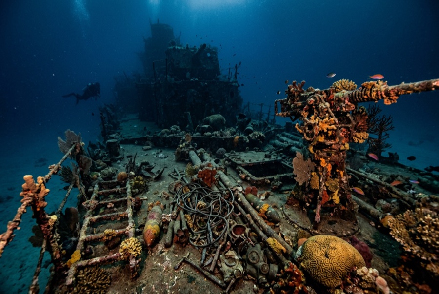
Million Dollar Point — illustrative image

Million Dollar Point

Second World War military equipment dump (debris field, not a vessel) Ditenggelamkan 1945 1–40 m Espiritu Santo
Ilustrasi hasil AI
Ada nyawa yang melayang di siniNone. Operator lokal meminta agar bangkai kapal ini diselami dengan rasa hormat yang sepadan.
Terdokumentasi
Kedalaman ke dek
1 m / 3 ft
Kedalaman maksimum
40 m / 131 ft
Dibangun / ditenggelamkan
? / 1945
Orientasi
A Jumbled Slope Of Machinery From The Shoreline Into Deep Water
Level
Beginner
Bulan-bulan terbaik
Apr–Oct

Kisahnya

When the Pacific war ended, Espiritu Santo held one of the largest American bases on earth, and shipping mountains of used equipment home made no economic sense. The story told on Santo — supported by what lies on the seabed — is that the US offered the lot to the Anglo-French authorities at a token price, the local administration stalled in the expectation of getting it free, and the Americans answered by building a ramp and driving the inventory into the sea: bulldozers, six-wheeled trucks, jeeps, cranes, forklifts, sheet steel, engines, and crate upon crate of stores, with Coca-Cola bottles beyond counting. The name records the estimated value of what went over. Today the point is a shore dive down a slope of interlocked machinery, axles and tracks fused by coral into a single sardonic monument to logistics. Two later shipwrecks lie among the debris, casualties of salvage attempts on the very metal being thrown away.

Bagaimana kapal ini tenggelam: US forces deliberately dumped surplus equipment into the sea at the end of the war after disposal negotiations failed.

Menyelaminya hari ini

Kondisi: A rust garden in slow collapse; recognizable machines emerge and disappear as the pile settles and storms rearrange the shallows.

Penetrasi: None. There is no hull to enter — only unstable stacked machinery, and wriggling into gaps between forty-ton machines is how divers get hurt.

Sertifikasi yang disarankan: Open Water

Arus: Mild · Visibilitas: 5–15 m

Kehidupan laut: Corals colonize axles and cab frames, octopus den in engine blocks, lionfish and sweepers fill the truck beds, and reef fish swarm the shallows where snorkelers drift.

Bahaya: Sharp, unstable metal throughout; surge in the shallows; broken glass near the old bottle dumps.

Perlindungan & hukum

Protected alongside the Coolidge under Vanuatu's wreck-site rules; local fees apply at the shore entry.

Bottles and brass have walked away for decades — the site is protected now, so leave every piece in the pile.

Tonton

Dari saluran resmi

Semua video →

Video adalah tautan sematan ke kanal milik kreatornya sendiri — kami tidak meng-host apa pun dan selalu mencantumkan kredit.

Sumber: Vanuatu Tourism ↗Wikipedia ↗ · Fakta diverifikasi terhadap sumber-sumber di atas; kolom yang belum didukung data diberi label belum diverifikasi.

Australia, Selandia Baru & Asia Timur

Cairns & the Ribbon ReefsNingaloo ReefCoral Sea & Osprey ReefOkinawa & the Kerama IslandsPoor Knights IslandsTownsville & the YongalaGreen IslandIzu Peninsula

Karibia & Atlantik Barat

BonaireCozumelRiviera Maya & the CenotesBelize Barrier ReefGrand CaymanIsla Mujeres & CancúnRoatánTiger Beach & Grand Bahama

Eropa, Atlantik & Mediterania

Malta & GozoSilfra & IcelandThe AzoresCanary IslandsLarnaca & the ZenobiaScapa FlowArctic NorwayMadeira

Samudra Hindia & Afrika Timur

North & South Malé AtollsAri AtollBaa Atoll & Hanifaru BayAliwal Shoal & UmkomaasMafia IslandMauritiusSeychellesSodwana Bay

Kepulauan Pasifik & Mikronesia

PalauChuuk (Truk) LagoonFakaravaKona, HawaiʻiRangiroaTaveuni & Rainbow ReefBeqa Lagoon & Pacific HarbourEspiritu Santo

Laut Merah & Timur Tengah

Sharm El Sheikh & Ras MohammedBrothers, Daedalus & St John'sDahabHurghada & El GounaMarsa Alam & the Deep SouthAqabaDaymaniyat IslandsMusandam Peninsula

Asia Tenggara & Segitiga Terumbu Karang

Bali & Nusa PenidaKomodoRaja AmpatSipadan & MabulAnilaoCoronKoh TaoLembeh Strait

Amerika & Pasifik Timur

Galápagos IslandsCocos IslandFlorida KeysSea of Cortez & Cabo PulmoSocorro & the RevillagigedosBritish ColumbiaCalifornia Channel IslandsCosta Rica Pacific Coast