Puntos de buceo, temporadas y vida marina — investigados, cartografiados, planificados.
Menú
Destinos Puntos de buceo Vida marina Pecios Noticias
Planifica un viaje Planificador de viajes Cuándo bucear Calculadora de costes Comparativas Calendario de fauna marina Temperatura del agua Liveaboards Operadores y resorts Parques marinos Cámaras hiperbáricas Mapa mundial
Regiones Australia, Nueva Zelanda y Asia OrientalCaribe y Atlántico occidentalEuropa, Atlántico y MediterráneoOcéano Índico y África OrientalIslas del Pacífico y MicronesiaMar Rojo y Oriente MedioSudeste Asiático y el Triángulo del CoralLas Américas y el Pacífico Oriental Países
Aprender y herramientas Todas las guías Certificaciones Guías de equipo Vídeos Consulta los datos Agentes de IA API
Acerca de Quiénes somos Metodología Aviso legal Contacto
Tu vista
★ Guardado

Tus destinos, sitios y especies favoritos — guardados en este navegador.

API GATEWAY

Acceso JSON gratuito de solo lectura a los datos en caché del atlas.

Modo oscuro

🧭 Vista guiada
¿Nuevo en el buceo? ¿Profundidades, corrientes, niveles de certificación? Explicamos cada término mientras navegas, en un lenguaje claro. Los mismos datos, con la ayuda integrada.

⚡ Vista experta
Ya conoces la diferencia entre una pared y un drift dive. Solo los datos — claros, rápidos y concisos. Esta es la vista predeterminada.

Idioma de la interfaz
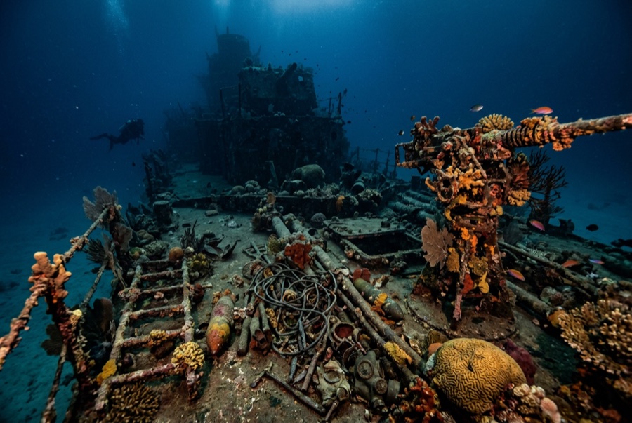
Okikawa Maru — illustrative image

Okikawa Maru

Japanese civilian fleet tanker Hundido 1944 10–26 m Coron
Ilustración generada por IA
Documentado
Profundidad hasta cubierta
10 m / 33 ft
Profundidad máxima
26 m / 85 ft
Construido / hundido
1938 / 1944
Longitud
168 m
Orientación
Upright
Nivel
Intermediate
Mejores meses
Dec–May

La historia

For decades dive guides called this ship the Taiei Maru, and the wrong name still surfaces in briefings — wreck identification in Coron was untangled slowly, from rivet counts and archival manifests. She was the Okikawa Maru, a big civilian tanker of the late 1930s pressed into naval service to move the fuel that Japan's war ran on. Anchored off Concepcion when the September 1944 carrier raid swept Coron Bay, she was hit and left burning, and air attacks in early October put her on the bottom for good. She settled upright in comfortable depths, which is why she has become the most dived wreck in the bay: her main deck lies shallow enough for long, unhurried tours, and her pump rooms and long tunnel-like passages give wreck students their first taste of overhead. The bow section, wrenched by the attacks, drops away in a tangle that rewards a slow look. Corals have made a garden of her catwalks.

Cómo se hundió: Damaged in the 24 September 1944 Coron raid and finished by follow-up air attacks in October 1944.

Buceando aquí hoy

Condición: Upright and diveable end to end, though the bow area is heavily broken and the hull is softening after eighty years.

Penetración: Full With Training. The engine room and fore-and-aft passageways are Coron's classic guided penetrations; training and a guide are expected, and silt punishes poor trim. Acceder a cualquier entorno de penetración exige formación específica — como mínimo una certificación en pecios, y formación técnica en pecios para penetración completa.

Certificación recomendada: Advanced Open Water; wreck training for interiors

Corriente: Mild · Visibilidad: 5–15 m

Vida marina: Hard and soft corals across the deck, sweetlips and batfish in the shade of the superstructure, banded sea kraits hunting the plating, turtles overhead.

Riesgos: Visibility can fall to a few meters; interior silt; occasional current over the bow.

Protección y legislación

Protected wartime wreck; Coron local dive fees apply.

Portholes and fittings stay on the ship — removal is prohibited.

Ver

Desde los canales oficiales

Todos los vídeos →

Los vídeos son enlaces incrustados a los canales propios de sus creadores — no alojamos nada y acreditamos todo.

Fuentes: CombinedFleet.com ↗PacificWrecks.com ↗ · Datos verificados frente a las fuentes anteriores; los campos sin respaldo se marcan como aún no verificados.

Australia, Nueva Zelanda y Asia Oriental

Cairns & the Ribbon ReefsNingaloo ReefCoral Sea & Osprey ReefOkinawa & the Kerama IslandsPoor Knights IslandsTownsville & the YongalaGreen IslandIzu Peninsula

Caribe y Atlántico occidental

BonaireCozumelRiviera Maya & the CenotesBelize Barrier ReefGrand CaymanIsla Mujeres & CancúnRoatánTiger Beach & Grand Bahama

Europa, Atlántico y Mediterráneo

Malta & GozoSilfra & IcelandThe AzoresCanary IslandsLarnaca & the ZenobiaScapa FlowArctic NorwayMadeira

Océano Índico y África Oriental

North & South Malé AtollsAri AtollBaa Atoll & Hanifaru BayAliwal Shoal & UmkomaasMafia IslandMauritiusSeychellesSodwana Bay

Islas del Pacífico y Micronesia

PalauChuuk (Truk) LagoonFakaravaKona, HawaiʻiRangiroaTaveuni & Rainbow ReefBeqa Lagoon & Pacific HarbourEspiritu Santo

Mar Rojo y Oriente Medio

Sharm El Sheikh & Ras MohammedBrothers, Daedalus & St John'sDahabHurghada & El GounaMarsa Alam & the Deep SouthAqabaDaymaniyat IslandsMusandam Peninsula

Sudeste Asiático y el Triángulo del Coral

Bali & Nusa PenidaKomodoRaja AmpatSipadan & MabulAnilaoCoronKoh TaoLembeh Strait

Las Américas y el Pacífico Oriental

Galápagos IslandsCocos IslandFlorida KeysSea of Cortez & Cabo PulmoSocorro & the RevillagigedosBritish ColumbiaCalifornia Channel IslandsCosta Rica Pacific Coast