Tauchplätze, Saisons und Meereslebewesen – recherchiert, kartiert, geplant.
Menü
Reiseziele Tauchplätze Meeresleben Wracks News
Eine Reise planen Tauchtrip-Planer Wann tauchen Kostenrechner Vergleiche Meereslebewesen-Kalender Wassertemperatur Liveaboards Tauchbetriebe & Resorts Meeresschutzgebiete Druckkammern Weltkarte
Regionen Australien, Neuseeland & OstasienKaribik & WestatlantikEuropa, Atlantik & MittelmeerIndischer Ozean & OstafrikaPazifikinseln & MikronesienRotes Meer & Naher OstenSüdostasien & Korallen-DreieckAmerika & Östlicher Pazifik Länder
Lernen & Tools Alle Guides Zertifizierungen Ausrüstungsratgeber Videos Daten abfragen KI-Agenten API
Über uns Über uns Methodik Haftungsausschluss Kontakt
Deine Ansicht
★ Gespeichert

Deine gespeicherten Reiseziele, Tauchplätze und Tierarten — im Browser gespeichert.

API-GATEWAY

Kostenloser, schreibgeschützter JSON-Zugriff auf die gecachten Daten des Atlas.

Dunkelmodus

🧭 Geführte Ansicht
Neu beim Tauchen — Tiefen, Strömungen, Zertifizierungsstufen? Wir erklären jeden Begriff beim Stöbern in verständlicher Sprache. Dieselben Daten, mit integrierter Hilfe.

⚡ Expertenansicht
Du kennst den Unterschied zwischen einem Wall und einem Drift Dive. Nur die Daten – klar, schnell und kompakt. Das ist die Standardansicht.

Oberflächensprache
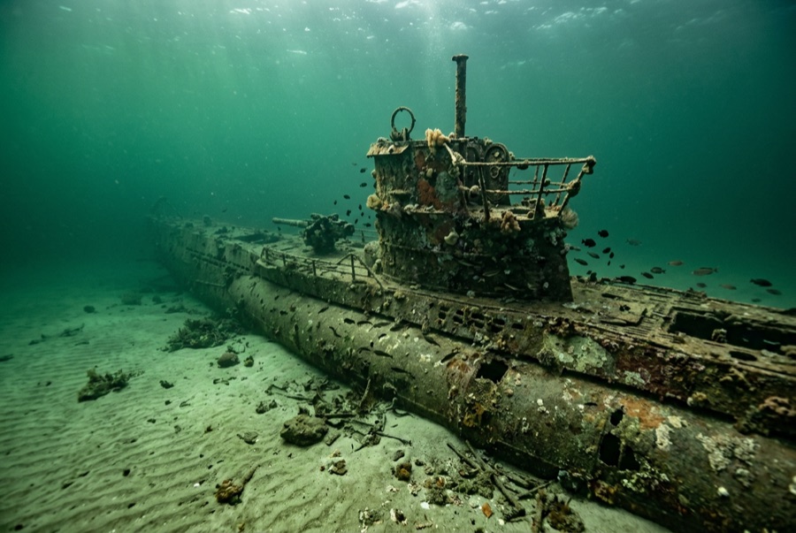
U-352 — illustrative image

U-352

German Type VIIC U-boat Gesunken 1942 27–35 m North Carolina Outer Banks
KI-generierte Illustration
Kriegsgrab Hier sind Menschen gestorben und liegen in manchen Fällen noch an Bord. Tauche dieses Wrack so, wie du ein Mahnmal besuchen würdest: nichts berühren, nichts mitnehmen, nichts stören. Roughly 13 to 15 of her crew died; 33 survivors were taken prisoner.
Gut dokumentiert
Tiefe zum Wrackdeck
27 m / 89 ft
Maximale Tiefe
35 m / 115 ft
Gebaut / versenkt
1941 / 1942
Länge
67 m
Orientierung
Upright With Slight Starboard List
Level
Advanced
Beste Monate
May–Oct

Die Geschichte dahinter

In the spring of 1942, U-boats were sinking ships almost unopposed along the US East Coast — the stretch off North Carolina earned the name Torpedo Junction. U-352 arrived hunting that traffic and found none of the easy victories her captain expected. On 9 May 1942 she fired on the Coast Guard cutter Icarus, missed, and was hammered by depth charges until Kapitänleutnant Hellmut Rathke surfaced and ordered abandon ship. Icarus's guns and the sinking took over a dozen of the crew; 33 survivors were pulled from the water and became among the first German prisoners of war taken by US forces in the Atlantic war. The submarine settled on sand at about 35 meters, where Gulf Stream water keeps her startlingly visible: an intact pressure hull with a slight starboard list, conning tower standing, outer plating long rusted away to show her skeleton. Divers treat her as what she is — a war grave holding German sailors. Enter nothing, take nothing; human remains have been encountered here in past decades, and both US law and simple decency protect the boat.

Wie sie sank: Depth-charged and sunk by the US Coast Guard cutter Icarus off Morehead City, 9 May 1942.

Heute dort tauchen

Bedingung: Pressure hull intact and coherent; outer casing and deck fittings largely gone after eight decades

Wrackinnenraum-Tauchen: None. The interior is a war grave and effectively sealed; entry is both prohibited in spirit and physically dangerous.

Empfohlene Zertifizierung: Advanced Open Water with deep experience

Strömung: Moderate · Sichtweite: 10–30 m

Meeresleben: Amberjack and barracuda circle the tower, queen angelfish pick at the hull, sand tiger sharks drift over from neighboring wrecks, and baitfish sheet along the pressure hull in summer.

Gefahren: Depth, offshore current, fishing line, and summer thermoclines; seas here change fast

Schutz & Recht

War grave of the German navy, protected under the US Sunken Military Craft Act — no entry, no removal of anything

Artifacts recovered in earlier, less careful decades are museum matters now; today the boat is dived on a strict look-only basis.

Ansehen

Aus den offiziellen Kanälen

Alle Videos →

Videos sind eingebettete Links zu den Kanälen der jeweiligen Ersteller – wir hosten nichts und geben für alles die Quelle an.

Quellen: NOAA ↗uboat.net ↗ · Fakten wurden anhand der oben genannten Quellen verifiziert; Felder ohne Quellenbeleg sind als noch nicht verifiziert gekennzeichnet.

Australien, Neuseeland & Ostasien

Cairns & the Ribbon ReefsNingaloo ReefCoral Sea & Osprey ReefOkinawa & the Kerama IslandsPoor Knights IslandsTownsville & the YongalaGreen IslandIzu Peninsula

Karibik & Westatlantik

BonaireCozumelRiviera Maya & the CenotesBelize Barrier ReefGrand CaymanIsla Mujeres & CancúnRoatánTiger Beach & Grand Bahama

Europa, Atlantik & Mittelmeer

Malta & GozoSilfra & IcelandThe AzoresCanary IslandsLarnaca & the ZenobiaScapa FlowArctic NorwayMadeira

Indischer Ozean & Ostafrika

North & South Malé AtollsAri AtollBaa Atoll & Hanifaru BayAliwal Shoal & UmkomaasMafia IslandMauritiusSeychellesSodwana Bay

Pazifikinseln & Mikronesien

PalauChuuk (Truk) LagoonFakaravaKona, HawaiʻiRangiroaTaveuni & Rainbow ReefBeqa Lagoon & Pacific HarbourEspiritu Santo

Rotes Meer & Naher Osten

Sharm El Sheikh & Ras MohammedBrothers, Daedalus & St John'sDahabHurghada & El GounaMarsa Alam & the Deep SouthAqabaDaymaniyat IslandsMusandam Peninsula

Südostasien & Korallen-Dreieck

Bali & Nusa PenidaKomodoRaja AmpatSipadan & MabulAnilaoCoronKoh TaoLembeh Strait

Amerika & Östlicher Pazifik

Galápagos IslandsCocos IslandFlorida KeysSea of Cortez & Cabo PulmoSocorro & the RevillagigedosBritish ColumbiaCalifornia Channel IslandsCosta Rica Pacific Coast