Puntos de buceo, temporadas y vida marina — investigados, cartografiados, planificados.
Menú
Destinos Puntos de buceo Vida marina Pecios Noticias
Planifica un viaje Planificador de viajes Cuándo bucear Calculadora de costes Comparativas Calendario de fauna marina Temperatura del agua Liveaboards Operadores y resorts Parques marinos Cámaras hiperbáricas Mapa mundial
Regiones Australia, Nueva Zelanda y Asia OrientalCaribe y Atlántico occidentalEuropa, Atlántico y MediterráneoOcéano Índico y África OrientalIslas del Pacífico y MicronesiaMar Rojo y Oriente MedioSudeste Asiático y el Triángulo del CoralLas Américas y el Pacífico Oriental Países
Aprender y herramientas Todas las guías Certificaciones Guías de equipo Vídeos Consulta los datos Agentes de IA API
Acerca de Quiénes somos Metodología Aviso legal Contacto
Tu vista
★ Guardado

Tus destinos, sitios y especies favoritos — guardados en este navegador.

API GATEWAY

Acceso JSON gratuito de solo lectura a los datos en caché del atlas.

Modo oscuro

🧭 Vista guiada
¿Nuevo en el buceo? ¿Profundidades, corrientes, niveles de certificación? Explicamos cada término mientras navegas, en un lenguaje claro. Los mismos datos, con la ayuda integrada.

⚡ Vista experta
Ya conoces la diferencia entre una pared y un drift dive. Solo los datos — claros, rápidos y concisos. Esta es la vista predeterminada.

Idioma de la interfaz
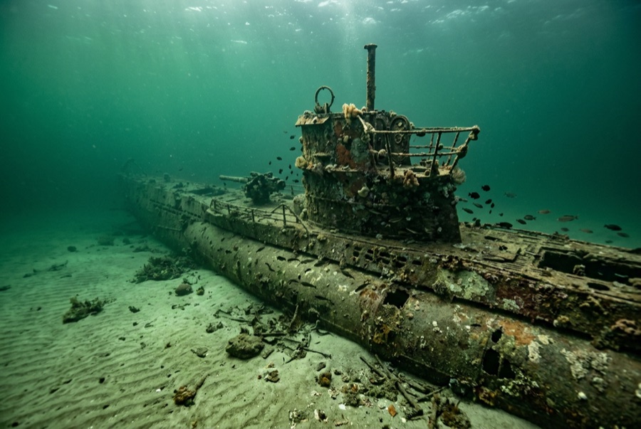
U-352 — illustrative image

U-352

German Type VIIC U-boat Hundido 1942 27–35 m North Carolina Outer Banks
Ilustración generada por IA
Tumba de guerra Aquí murieron personas que, en algunos casos, siguen a bordo. Bucea en este lugar como si visitaras un memorial: no toques, no te lleves nada, no perturbes nada. Roughly 13 to 15 of her crew died; 33 survivors were taken prisoner.
Bien documentado
Profundidad hasta cubierta
27 m / 89 ft
Profundidad máxima
35 m / 115 ft
Construido / hundido
1941 / 1942
Longitud
67 m
Orientación
Upright With Slight Starboard List
Nivel
Advanced
Mejores meses
May–Oct

La historia

In the spring of 1942, U-boats were sinking ships almost unopposed along the US East Coast — the stretch off North Carolina earned the name Torpedo Junction. U-352 arrived hunting that traffic and found none of the easy victories her captain expected. On 9 May 1942 she fired on the Coast Guard cutter Icarus, missed, and was hammered by depth charges until Kapitänleutnant Hellmut Rathke surfaced and ordered abandon ship. Icarus's guns and the sinking took over a dozen of the crew; 33 survivors were pulled from the water and became among the first German prisoners of war taken by US forces in the Atlantic war. The submarine settled on sand at about 35 meters, where Gulf Stream water keeps her startlingly visible: an intact pressure hull with a slight starboard list, conning tower standing, outer plating long rusted away to show her skeleton. Divers treat her as what she is — a war grave holding German sailors. Enter nothing, take nothing; human remains have been encountered here in past decades, and both US law and simple decency protect the boat.

Cómo se hundió: Depth-charged and sunk by the US Coast Guard cutter Icarus off Morehead City, 9 May 1942.

Buceando aquí hoy

Condición: Pressure hull intact and coherent; outer casing and deck fittings largely gone after eight decades

Penetración: None. The interior is a war grave and effectively sealed; entry is both prohibited in spirit and physically dangerous.

Certificación recomendada: Advanced Open Water with deep experience

Corriente: Moderate · Visibilidad: 10–30 m

Vida marina: Amberjack and barracuda circle the tower, queen angelfish pick at the hull, sand tiger sharks drift over from neighboring wrecks, and baitfish sheet along the pressure hull in summer.

Riesgos: Depth, offshore current, fishing line, and summer thermoclines; seas here change fast

Protección y legislación

War grave of the German navy, protected under the US Sunken Military Craft Act — no entry, no removal of anything

Artifacts recovered in earlier, less careful decades are museum matters now; today the boat is dived on a strict look-only basis.

Ver

Desde los canales oficiales

Todos los vídeos →

Los vídeos son enlaces incrustados a los canales propios de sus creadores — no alojamos nada y acreditamos todo.

Fuentes: NOAA ↗uboat.net ↗ · Datos verificados frente a las fuentes anteriores; los campos sin respaldo se marcan como aún no verificados.

Australia, Nueva Zelanda y Asia Oriental

Cairns & the Ribbon ReefsNingaloo ReefCoral Sea & Osprey ReefOkinawa & the Kerama IslandsPoor Knights IslandsTownsville & the YongalaGreen IslandIzu Peninsula

Caribe y Atlántico occidental

BonaireCozumelRiviera Maya & the CenotesBelize Barrier ReefGrand CaymanIsla Mujeres & CancúnRoatánTiger Beach & Grand Bahama

Europa, Atlántico y Mediterráneo

Malta & GozoSilfra & IcelandThe AzoresCanary IslandsLarnaca & the ZenobiaScapa FlowArctic NorwayMadeira

Océano Índico y África Oriental

North & South Malé AtollsAri AtollBaa Atoll & Hanifaru BayAliwal Shoal & UmkomaasMafia IslandMauritiusSeychellesSodwana Bay

Islas del Pacífico y Micronesia

PalauChuuk (Truk) LagoonFakaravaKona, HawaiʻiRangiroaTaveuni & Rainbow ReefBeqa Lagoon & Pacific HarbourEspiritu Santo

Mar Rojo y Oriente Medio

Sharm El Sheikh & Ras MohammedBrothers, Daedalus & St John'sDahabHurghada & El GounaMarsa Alam & the Deep SouthAqabaDaymaniyat IslandsMusandam Peninsula

Sudeste Asiático y el Triángulo del Coral

Bali & Nusa PenidaKomodoRaja AmpatSipadan & MabulAnilaoCoronKoh TaoLembeh Strait

Las Américas y el Pacífico Oriental

Galápagos IslandsCocos IslandFlorida KeysSea of Cortez & Cabo PulmoSocorro & the RevillagigedosBritish ColumbiaCalifornia Channel IslandsCosta Rica Pacific Coast