Duiksites, seizoenen en zeeleven — onderzocht, in kaart gebracht, gepland.
Menu
Bestemmingen Duiklocaties Zeeleven Wrakken Nieuws
Plan een reis Reisplanner Wanneer duiken Kostencalculator Vergelijkingen Zeeleven-kalender Watertemperatuur Liveaboards Operators & resorts Mariene parken Hyperbare kamers Wereldkaart
Regio's Australië, Nieuw-Zeeland & Oost-AziëCaribisch gebied & westelijke Atlantische OceaanEuropa, Atlantische Oceaan & Middellandse ZeeIndische Oceaan & Oost-AfrikaPacifische eilanden & MicronesiëRode Zee & Midden-OostenZuidoost-Azië & Coral TriangleDe Amerika's & Oost-Stille Oceaan Landen
Leren & Tools Alle gidsen Brevetten Uitrustingsgidsen Video's Vraag de data AI-agents API
Over Over ons Methodologie Disclaimer Contact
Jouw weergave
★ Opgeslagen

Jouw favoriete bestemmingen, duiklocaties en soorten — opgeslagen in deze browser.

API GATEWAY

Gratis alleen-lezen JSON-toegang tot de gecachede data van de atlas.

Donkere modus

🧭 Begeleide weergave
Nieuw met duiken — dieptes, stromingen, brevetniveaus? We leggen elke term uit terwijl je bladert, in gewone taal. Dezelfde gegevens, met ingebouwde uitleg.

⚡ Expertweergave
Je weet het verschil tussen een wand en een drift dive al. Alleen de data — overzichtelijk, snel en compact. Dit is de standaardweergave.

Interfacetaal
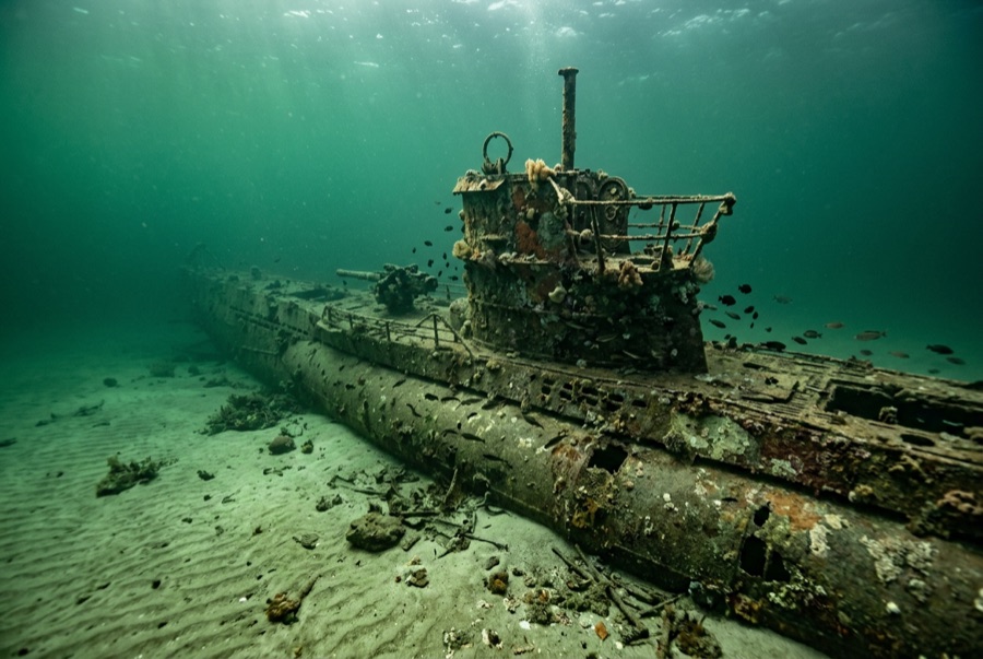
U-352 — illustrative image

U-352

German Type VIIC U-boat Gezonken 1942 27–35 m North Carolina Outer Banks
AI-gegenereerde illustratie
Oorlogsgraf Mensen zijn hier omgekomen en verblijven in sommige gevallen nog aan boord. Duik hier zoals je een herdenkingsplaats zou bezoeken: niets aanraken, niets meenemen, niets verstoren. Roughly 13 to 15 of her crew died; 33 survivors were taken prisoner.
Goed gedocumenteerd
Diepte tot dek
27 m / 89 ft
Maximale diepte
35 m / 115 ft
Gebouwd / gezonken
1941 / 1942
Lengte
67 m
Oriëntatie
Upright With Slight Starboard List
Niveau
Advanced
Beste maanden
May–Oct

Het verhaal

In the spring of 1942, U-boats were sinking ships almost unopposed along the US East Coast — the stretch off North Carolina earned the name Torpedo Junction. U-352 arrived hunting that traffic and found none of the easy victories her captain expected. On 9 May 1942 she fired on the Coast Guard cutter Icarus, missed, and was hammered by depth charges until Kapitänleutnant Hellmut Rathke surfaced and ordered abandon ship. Icarus's guns and the sinking took over a dozen of the crew; 33 survivors were pulled from the water and became among the first German prisoners of war taken by US forces in the Atlantic war. The submarine settled on sand at about 35 meters, where Gulf Stream water keeps her startlingly visible: an intact pressure hull with a slight starboard list, conning tower standing, outer plating long rusted away to show her skeleton. Divers treat her as what she is — a war grave holding German sailors. Enter nothing, take nothing; human remains have been encountered here in past decades, and both US law and simple decency protect the boat.

Hoe ze zonk: Depth-charged and sunk by the US Coast Guard cutter Icarus off Morehead City, 9 May 1942.

Duik er vandaag in

Conditie: Pressure hull intact and coherent; outer casing and deck fittings largely gone after eight decades

Penetratieduiken: None. The interior is a war grave and effectively sealed; entry is both prohibited in spirit and physically dangerous.

Aanbevolen certificering: Advanced Open Water with deep experience

Stroming: Moderate · Zicht: 10–30 m

Zeeleven: Amberjack and barracuda circle the tower, queen angelfish pick at the hull, sand tiger sharks drift over from neighboring wrecks, and baitfish sheet along the pressure hull in summer.

Gevaren: Depth, offshore current, fishing line, and summer thermoclines; seas here change fast

Bescherming & wetgeving

War grave of the German navy, protected under the US Sunken Military Craft Act — no entry, no removal of anything

Artifacts recovered in earlier, less careful decades are museum matters now; today the boat is dived on a strict look-only basis.

Bekijk

Via de officiële kanalen

Alle video's →

Video's zijn ingesloten links naar de kanalen van de makers zelf — wij hosten niets en vermelden altijd de bron.

Bronnen: NOAA ↗uboat.net ↗ · Feiten geverifieerd aan de hand van bovenstaande bronnen; velden zonder onderbouwing zijn aangemerkt als nog niet geverifieerd.

Australië, Nieuw-Zeeland & Oost-Azië

Cairns & the Ribbon ReefsNingaloo ReefCoral Sea & Osprey ReefOkinawa & the Kerama IslandsPoor Knights IslandsTownsville & the YongalaGreen IslandIzu Peninsula

Caribisch gebied & westelijke Atlantische Oceaan

BonaireCozumelRiviera Maya & the CenotesBelize Barrier ReefGrand CaymanIsla Mujeres & CancúnRoatánTiger Beach & Grand Bahama

Europa, Atlantische Oceaan & Middellandse Zee

Malta & GozoSilfra & IcelandThe AzoresCanary IslandsLarnaca & the ZenobiaScapa FlowArctic NorwayMadeira

Indische Oceaan & Oost-Afrika

North & South Malé AtollsAri AtollBaa Atoll & Hanifaru BayAliwal Shoal & UmkomaasMafia IslandMauritiusSeychellesSodwana Bay

Pacifische eilanden & Micronesië

PalauChuuk (Truk) LagoonFakaravaKona, HawaiʻiRangiroaTaveuni & Rainbow ReefBeqa Lagoon & Pacific HarbourEspiritu Santo

Rode Zee & Midden-Oosten

Sharm El Sheikh & Ras MohammedBrothers, Daedalus & St John'sDahabHurghada & El GounaMarsa Alam & the Deep SouthAqabaDaymaniyat IslandsMusandam Peninsula

Zuidoost-Azië & Coral Triangle

Bali & Nusa PenidaKomodoRaja AmpatSipadan & MabulAnilaoCoronKoh TaoLembeh Strait

De Amerika's & Oost-Stille Oceaan

Galápagos IslandsCocos IslandFlorida KeysSea of Cortez & Cabo PulmoSocorro & the RevillagigedosBritish ColumbiaCalifornia Channel IslandsCosta Rica Pacific Coast