Sites de plongée, saisons et vie marine — recherchés, cartographiés, planifiés.
Menu
Destinations Sites de plongée Vie marine Épaves Actualités
Planifier un voyage Planificateur de séjour Quand plonger Calculateur de coût Comparaisons Calendrier de la faune marine Température de l'eau Liveaboards Opérateurs & resorts Parcs marins Caissons hyperbares Carte du monde
Régions Australie, Nouvelle-Zélande & Asie de l'EstCaraïbes & Atlantique occidentalEurope, Atlantique & MéditerranéeOcéan Indien & Afrique de l'EstÎles du Pacifique & MicronésieMer Rouge & Moyen-OrientAsie du Sud-Est et Triangle de CorailLes Amériques et Pacifique Est Pays
Apprendre & Outils Tous les guides Certifications Guides d'équipement Vidéos Interroger les données Agents IA API
À propos À propos de nous Méthodologie Avertissement Contact
Votre vue
★ Enregistré

Vos destinations, sites et espèces favoris — enregistrés dans ce navigateur.

API GATEWAY

Accès JSON gratuit en lecture seule aux données en cache de l'atlas.

Mode sombre

🧭 Vue Guidée
Nouveau dans la plongée — profondeurs, courants, niveaux de certification ? Nous expliquons chaque terme au fil de votre navigation, en langage clair. Les mêmes données, avec l'aide intégrée.

⚡ Vue Expert
Vous connaissez déjà la différence entre un tombant et un drift. Juste les données — claires, rapides et compactes. C'est la vue par défaut.

Langue de l'interface
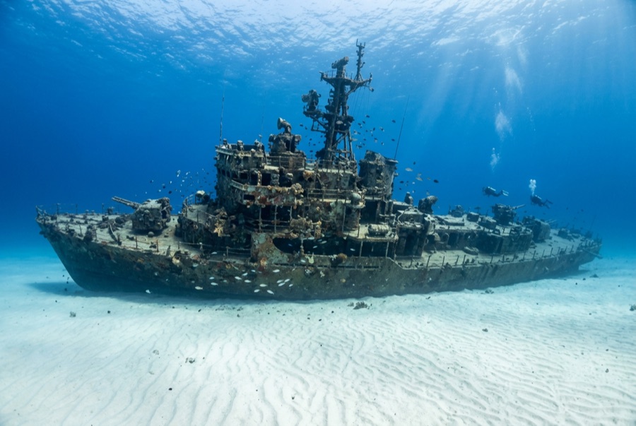
USCGC Duane — illustrative image

USCGC Duane

Treasury-class US Coast Guard cutter (WPG-33) Coulé 1987 18–37 m Florida Keys
Illustration générée par IA
Des vies ont été perdues iciNone (planned scuttling). Les opérateurs locaux demandent que l'épave soit plongée avec le respect qui s'impose.
Bien documenté
Profondeur jusqu'au pont
18 m / 59 ft
Profondeur maximale
37 m / 121 ft
Construit / coulé
1936 / 1987
Longueur
100 m
Orientation
Upright
Niveau
Advanced
Meilleurs mois
Apr–Sep

L'histoire

Few working ships earn a half-century of service as varied as the Duane's. Commissioned in 1936, the 327-foot cutter escorted North Atlantic convoys in the Second World War — taking part with her sister Spencer in the 1943 action that destroyed U-175 and rescuing survivors from the sea — then went on to weather-station duty, Vietnam gunfire support and decades of search-and-rescue and drug interdiction. When she was retired in 1985 she was the oldest active US military vessel afloat. Two years later she was cleaned and sent down south of Molasses Reef, one day after her sister ship Bibb, to seed the Keys' artificial-reef program. The two settled differently: the Bibb lies on her side in deeper water, while the Duane sits perfectly upright at about 37 meters, mast still standing, wheelhouse open to the blue. Bathed in Gulf Stream water, she has grown a vivid crust of sponge and coral and often delivers the clearest, fishiest big-wreck dive in the upper Keys — when the same current that feeds her allows a comfortable descent.

Comment elle a coulé: Deliberately scuttled as an artificial reef off Key Largo, 27 November 1987.

Plongée sur ce site aujourd'hui

Condition: Upright and notably intact, mast and crow's nest standing; among the most photogenic profiles in Florida wreck diving

Pénétration: Limited. Open hatches invite a look, but interior spaces are confined and silty; anything past the doorways is for trained wreck divers. Toute pénétration en environnement semi-fermé exige une formation spécifique — au minimum une certification épave, et une formation technique épave pour une pénétration complète.

Certification recommandée: Advanced Open Water

Courant: Strong · Visibilité: 15–30 m

Vie marine: Great barracuda stack in the current above the mast, horse-eye jacks wheel around the superstructure, goliath grouper visit the hull, and the rails bloom with encrusting sponge and cup corals.

Dangers: Strong current, depth, and fishing line snagged across the rigging

Protection & réglementation

Within Florida Keys National Marine Sanctuary — mooring buoys only, and artifact removal is prohibited

Regarder

Depuis les canaux officiels

Toutes les vidéos →

Les vidéos sont des liens intégrés vers les chaînes de leurs créateurs — nous n'hébergeons rien et créditons tout.

Sources: NOAA ↗US Coast Guard Historian's Office ↗ · Informations vérifiées par rapport aux sources ci-dessus ; les champs sans référence sont marqués non encore vérifiés.

Australie, Nouvelle-Zélande & Asie de l'Est

Cairns & the Ribbon ReefsNingaloo ReefCoral Sea & Osprey ReefOkinawa & the Kerama IslandsPoor Knights IslandsTownsville & the YongalaGreen IslandIzu Peninsula

Caraïbes & Atlantique occidental

BonaireCozumelRiviera Maya & the CenotesBelize Barrier ReefGrand CaymanIsla Mujeres & CancúnRoatánTiger Beach & Grand Bahama

Europe, Atlantique & Méditerranée

Malta & GozoSilfra & IcelandThe AzoresCanary IslandsLarnaca & the ZenobiaScapa FlowArctic NorwayMadeira

Océan Indien & Afrique de l'Est

North & South Malé AtollsAri AtollBaa Atoll & Hanifaru BayAliwal Shoal & UmkomaasMafia IslandMauritiusSeychellesSodwana Bay

Îles du Pacifique & Micronésie

PalauChuuk (Truk) LagoonFakaravaKona, HawaiʻiRangiroaTaveuni & Rainbow ReefBeqa Lagoon & Pacific HarbourEspiritu Santo

Mer Rouge & Moyen-Orient

Sharm El Sheikh & Ras MohammedBrothers, Daedalus & St John'sDahabHurghada & El GounaMarsa Alam & the Deep SouthAqabaDaymaniyat IslandsMusandam Peninsula

Asie du Sud-Est et Triangle de Corail

Bali & Nusa PenidaKomodoRaja AmpatSipadan & MabulAnilaoCoronKoh TaoLembeh Strait

Les Amériques et Pacifique Est

Galápagos IslandsCocos IslandFlorida KeysSea of Cortez & Cabo PulmoSocorro & the RevillagigedosBritish ColumbiaCalifornia Channel IslandsCosta Rica Pacific Coast