مواقع الغوص والمواسم والحياة البحرية — مبحوثة، ومرسومة على الخرائط، ومخطَّط لها.
القائمة
الوجهات مواقع الغوص الحياة البحرية حطام السفن الأخبار
خطّط لرحلة مخطّط الرحلات أفضل أوقات الغوص حاسبة التكاليف مقارنات تقويم الحياة البحرية درجة حرارة الماء الليفبوردات المشغّلون والمنتجعات المحميات البحرية غرف الضغط العالي خريطة العالم
المناطق أستراليا، نيوزيلندا وشرق آسياالبحر الكاريبي وغرب المحيط الأطلسيأوروبا والأطلسي والمتوسطالمحيط الهندي وشرق أفريقياجزر المحيط الهادئ وميكرونيزياالبحر الأحمر والشرق الأوسطجنوب شرق آسيا ومثلث الشعاب المرجانيةالأمريكتان والمحيط الهادئ الشرقي الدول
التعلّم والأدوات جميع الأدلة الشهادات أدلة المعدات مقاطع فيديو استفسر عن البيانات وكلاء الذكاء الاصطناعي API
حول من نحن المنهجية إخلاء المسؤولية تواصل معنا
عرضك
★ محفوظ

وجهاتك المفضّلة والمواقع والكائنات البحرية المُعلَّمة بنجمة — محفوظة في هذا المتصفح.

API GATEWAY

وصول JSON مجاني للقراءة فقط إلى البيانات المخزّنة في الأطلس.

الوضع الداكن

🧭 عرض المرشد
هل أنت جديد على الغوص — أعماق، تيارات، مستويات شهادات؟ نشرح كل مصطلح أثناء تصفّحك، بأسلوب بسيط وواضح. نفس البيانات، مع المساعدة المدمجة فيها.

⚡ عرض الخبراء
أنت تعرف الفرق بين الجدار والدريفت دايف. فقط البيانات — واضحة وسريعة ومختصرة. هذا هو العرض الافتراضي.

لغة الواجهة
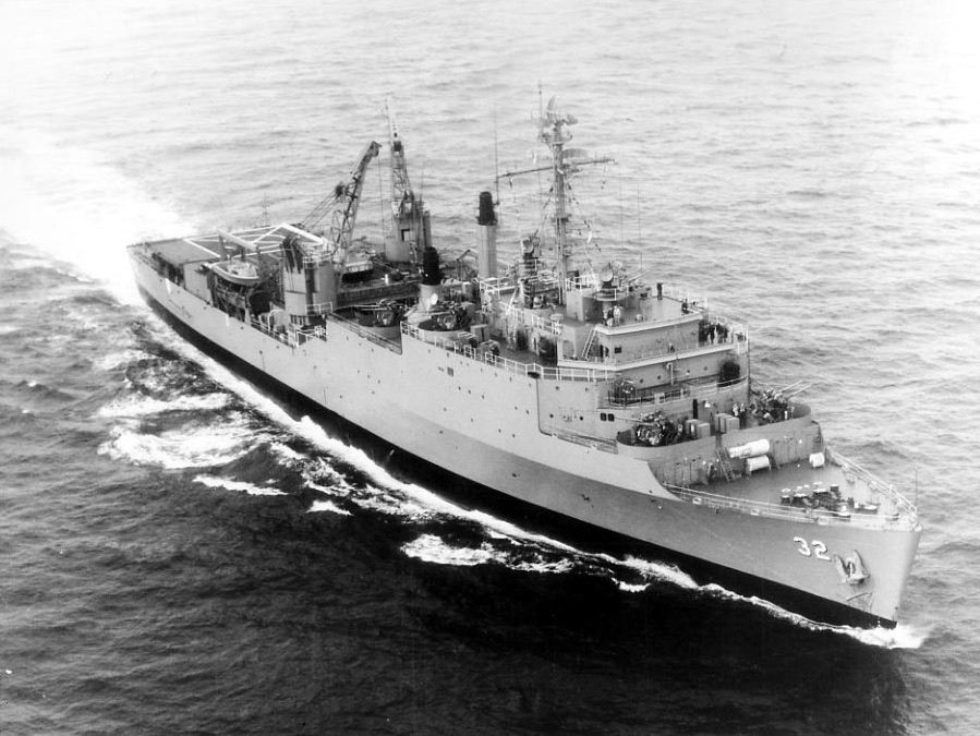
USS Spiegel Grove — illustrative image

USS Spiegel Grove

Thomaston-class dock landing ship (LSD-32) تاريخ الغرق 2002 18–40 m Florida Keys
رسم توضيحي من الذكاء الاصطناعي التوليدي
فُقدت أرواح هناNone (planned scuttling). يطلب المشغّلون المحليون أن يُغاص عند الحطام باحترام مماثل.
موثّق جيداً
العمق إلى السطح العلوي
18 m / 59 ft
الحد الأقصى للعمق
40 m / 131 ft
بُني / أُغرق
1955 / 2002
الطول
155 m
نظرة عامة
Upright Since Hurricane Dennis (2005)
المستوى
Advanced
أفضل الأشهر
Apr–Sep

القصة

Named for Rutherford B. Hayes's Ohio estate, the Spiegel Grove spent the Cold War hauling landing craft, vehicles and Marines in her floodable well deck. Key Largo's plan to sink the 155-meter ship as an artificial reef in May 2002 turned briefly farcical: she flooded prematurely, rolled, and sank hours ahead of schedule, coming to rest upside down with her bow poking above the surface. Salvage crews spent weeks that June wrestling her onto her starboard side, and divers learned the wreck tilted — until July 2005, when the storm surge of Hurricane Dennis did what the engineers could not and stood her perfectly upright on the sand at about 40 meters. That last twist completed one of diving's best-known origin stories. Today she is the signature big wreck of the upper Keys, an enormous gray canyon of davits, cranes and catwalks patrolled by goliath grouper, with mooring buoys marking her bow, amidships and stern. Her sheer scale rewards repeat visits; nobody sees the Spiegel Grove in one dive.

كيف غرقت: Deliberately scuttled as an artificial reef, 17 May 2002 — she sank hours early and capsized, was later rolled onto her side, and was pushed fully upright by Hurricane Dennis in 2005.

الغوص فيها اليوم

الحالة: Substantially intact and upright; superstructure, cranes and well deck all recognizable, with corals steadily claiming the rails

الغوص في الأماكن الضيقة (Penetration): Full With Training. Miles of interior passageway exist and several guided routes are established, but the ship has killed unprepared divers — true penetration belongs to teams with wreck or technical training, lights and lines. الدخول إلى أي بيئة محاطة يستلزم تدريبًا متخصصًا — شهادة الحطام كحدٍّ أدنى، والتدريب التقني على الاختراق الكامل للحطام عند الرغبة في الاستكشاف الكامل.

الشهادة الموصى بها: Advanced Open Water; wreck training for any interior

التيار: Moderate · الرؤية: 10–30 m

الحياة البحرية: Resident goliath grouper shadow divers along the well deck, great barracuda hold station off the kingposts, and angelfish, jacks and a growing coat of sponge and coral soften the steel.

المخاطر: Depth, current, monofilament snagged on the superstructure, and a vast interior that punishes casual entry

الحماية والتشريعات

Within Florida Keys National Marine Sanctuary — mooring buoys are mandatory and removing anything is prohibited

شاهد

من القنوات الرسمية

جميع الفيديوهات →

مقاطع الفيديو روابط مضمّنة لقنوات أصحابها أنفسهم — لا نستضيف شيئاً ونُشير إلى المصدر دائماً.

المصادر: NOAA ↗Wikipedia ↗ · المعلومات مُتحقَّق منها وفق المصادر أعلاه؛ والحقول غير المدعومة بمصدر مُصنَّفة بـ "لم يُتحقَّق منه بعد".

أستراليا، نيوزيلندا وشرق آسيا

Cairns & the Ribbon ReefsNingaloo ReefCoral Sea & Osprey ReefOkinawa & the Kerama IslandsPoor Knights IslandsTownsville & the YongalaGreen IslandIzu Peninsula

البحر الكاريبي وغرب المحيط الأطلسي

BonaireCozumelRiviera Maya & the CenotesBelize Barrier ReefGrand CaymanIsla Mujeres & CancúnRoatánTiger Beach & Grand Bahama

أوروبا والأطلسي والمتوسط

Malta & GozoSilfra & IcelandThe AzoresCanary IslandsLarnaca & the ZenobiaScapa FlowArctic NorwayMadeira

المحيط الهندي وشرق أفريقيا

North & South Malé AtollsAri AtollBaa Atoll & Hanifaru BayAliwal Shoal & UmkomaasMafia IslandMauritiusSeychellesSodwana Bay

جزر المحيط الهادئ وميكرونيزيا

PalauChuuk (Truk) LagoonFakaravaKona, HawaiʻiRangiroaTaveuni & Rainbow ReefBeqa Lagoon & Pacific HarbourEspiritu Santo

البحر الأحمر والشرق الأوسط

Sharm El Sheikh & Ras MohammedBrothers, Daedalus & St John'sDahabHurghada & El GounaMarsa Alam & the Deep SouthAqabaDaymaniyat IslandsMusandam Peninsula

جنوب شرق آسيا ومثلث الشعاب المرجانية

Bali & Nusa PenidaKomodoRaja AmpatSipadan & MabulAnilaoCoronKoh TaoLembeh Strait

الأمريكتان والمحيط الهادئ الشرقي

Galápagos IslandsCocos IslandFlorida KeysSea of Cortez & Cabo PulmoSocorro & the RevillagigedosBritish ColumbiaCalifornia Channel IslandsCosta Rica Pacific Coast