Descubre dónde bucear, cuándo ir y qué podrías ver.

Descubre dónde bucear, cuándo ir y qué podrías ver.
★
Menú
Destinos Puntos de buceo Vida marina Pecios Noticias
Planifica un viaje Planificador de viajes Cuándo bucear Calculadora de costes Comparativas Calendario de fauna marina Temperatura del agua Liveaboards Operadores y resorts Parques marinos Cámaras hiperbáricas Mapa mundial
Buceo en cuevas Todo sobre el buceo en cueva Destinos y sitios de buceo Sistemas de Cuevas y Mapas Formación y titulaciones Centros de buceo y guías Equipamiento y tecnología Seguridad e investigación de incidentes Ciencia, historia y conservación Recursos y actualizaciones
Regiones Australia, Nueva Zelanda y Asia OrientalCaribe y Atlántico occidentalEuropa, Atlántico y MediterráneoOcéano Índico y África OrientalIslas del Pacífico y MicronesiaMar Rojo y Oriente MedioSudeste Asiático y el Triángulo del CoralLas Américas y el Pacífico Oriental Países
Aprender y herramientas Todas las guías Certificaciones Guías de equipo Vídeos Consulta los datos Agentes de IA API
Acerca de Quiénes somos Metodología Aviso legal Contacto
Tu vista
★ Guardado

Tus destinos, puntos de buceo y especies marcados como favoritos, guardados en este navegador.

API GATEWAY

Acceso JSON gratuito de solo lectura a los datos en caché del atlas.

Modo oscuro

Vista guiada
¿Nuevo en el buceo? ¿Profundidades, corrientes, niveles de certificación? Explicamos cada término mientras navegas, en un lenguaje claro. Los mismos datos, con la ayuda integrada.

Vista experta
Ya conoces la diferencia entre una pared y un drift dive. Solo los datos: claros, rápidos y concisos. Esta es la vista predeterminada.

Idioma de la interfaz
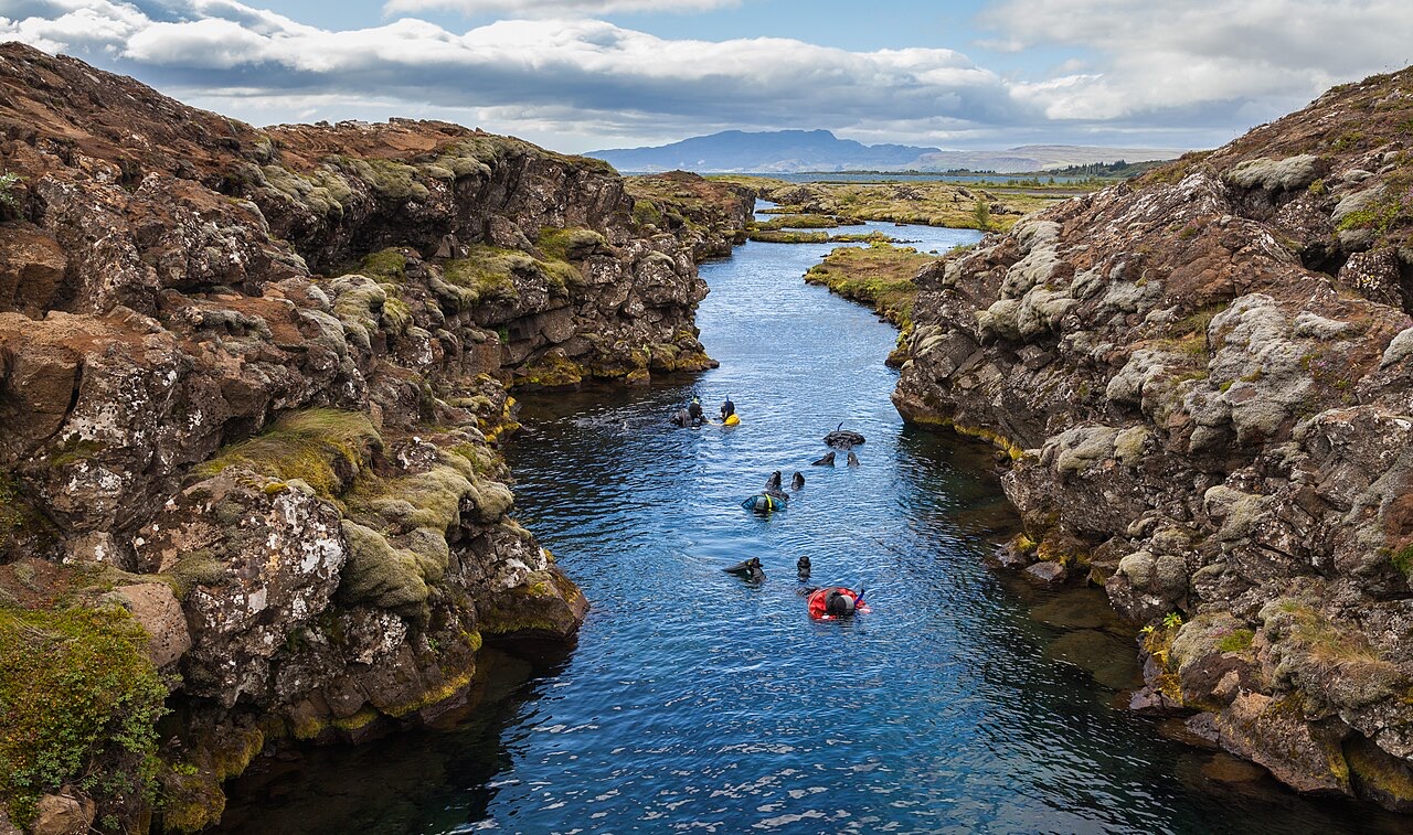
Snorkeling in the Silfra canyon , a rift between the tectonic plates (North American and Eurasian), Þingvellir National Park , Southern Region , Iceland .

Silfra Fissure

Freshwater 2–18 m Intermediate Silfra & Iceland, Iceland
Foto: Diego Delso · CC BY-SA 4.0
Bien documentado
Profundidad
2–18 m / 7–59 ft
Profundidad típica
10 m / 33 ft
Visibilidad
70–100 m / 230–328 ft
Agua
2–4 °C / 36–39 °F
Corriente
Mild
Acceso
Shore
Mejores meses
May–Sep
Certificación recomendada
Open Water plus drysuit certification or documented drysuit experience
Inmersión típica
~35 min

La profundidad es el rango desde la cima del punto de buceo hasta su máximo habitual; la "certificación recomendada" es el nivel que los operadores suelen pedir según las agencias principales, no una norma legal. Las corrientes y la visibilidad cambian a diario, así que trata todo esto como rangos de planificación.

Silfra is the rare dive whose reputation undersells it. The fissure is a crack in the rift valley where the North American and Eurasian plates separate, flooded by glacial water that has spent decades filtering through lava before surfacing at 2–4 °C, clean enough to drink mid-dive. Visibility runs to the length of the site itself: in the Cathedral section the entire hundred-meter canyon hangs in view at once, blue over black basalt, with green algae streamers the only vegetation. The profile is shallow and the flow does the work; cold hands and camera settings are the only real challenges.

El momento por el que vienes: Swimming a tectonic boundary, visibility beyond 80 m, drinkable glacier water, the Cathedral's blue perspective

Topografía: Basalt canyon walls and boulder floor through the sections Big Crack, Silfra Hall, Silfra Cathedral and Silfra Lagoon

Corriente: A gentle constant flow pushes divers along the fissure toward the lagoon: navigation mostly takes care of itself.

Entrada: Metal stairs at the entry and exit platforms inside Thingvellir National Park; all dives are guided and equipment is hauled from the nearby car park.

Lo que debes saber antes de tirarte al agua

Riesgos: Water at 2–4 °C: regulator free-flows, rapid hand numbing and short no-fuss dive times. Listen to the cold-water briefing.

Permisos y normas: Diving only through operators licensed by the park; drysuit prerequisite enforced; park fees apply.

Conservación: A protected site inside a UNESCO World Heritage national park: no touching the walls, no disturbing the algae, nothing removed.

Para fotógrafos

Gran angular: ★★★★★ · Macro: ★☆☆☆☆ (valoración de 1 a 5 de los editores sobre lo que ofrece este sitio para cada estilo de fotografía)

Australia, Nueva Zelanda y Asia Oriental

Cairns & the Ribbon ReefsNingaloo ReefCoral Sea & Osprey ReefOkinawa & the Kerama IslandsPoor Knights IslandsTownsville & the YongalaGreen IslandIzu Peninsula

Caribe y Atlántico occidental

BonaireCozumelRiviera Maya & the CenotesBelize Barrier ReefGrand CaymanIsla Mujeres & CancúnRoatánTiger Beach & Grand Bahama

Europa, Atlántico y Mediterráneo

Malta & GozoSilfra & IcelandThe AzoresCanary IslandsLarnaca & the ZenobiaScapa FlowArctic NorwayMadeira

Océano Índico y África Oriental

North & South Malé AtollsAri AtollBaa Atoll & Hanifaru BayAliwal Shoal & UmkomaasMafia IslandMauritiusSeychellesSodwana Bay

Islas del Pacífico y Micronesia

PalauChuuk (Truk) LagoonFakaravaKona, HawaiʻiRangiroaTaveuni & Rainbow ReefBeqa Lagoon & Pacific HarbourEspiritu Santo

Mar Rojo y Oriente Medio

Sharm El Sheikh & Ras MohammedBrothers, Daedalus & St John'sDahabHurghada & El GounaMarsa Alam & the Deep SouthAqabaDaymaniyat IslandsMusandam Peninsula

Sudeste Asiático y el Triángulo del Coral

Bali & Nusa PenidaKomodoRaja AmpatSipadan & MabulAnilaoCoronKoh TaoLembeh Strait

Las Américas y el Pacífico Oriental

Galápagos IslandsCocos IslandFlorida KeysSea of Cortez & Cabo PulmoSocorro & the RevillagigedosBritish ColumbiaCalifornia Channel IslandsCosta Rica Pacific Coast