Temukan tempat menyelam, waktu terbaik untuk pergi, dan apa yang bisa Anda lihat.

Temukan tempat menyelam, waktu terbaik untuk pergi, dan apa yang bisa Anda lihat.
★
Menu
Destinasi Lokasi Selam Kehidupan Laut Bangkai kapal Berita
Rencanakan perjalanan Perencana trip Kapan waktu terbaik menyelam Kalkulator biaya Perbandingan Kalender kehidupan laut Suhu air Liveaboard Operator & resor Taman laut Ruang hiperbarik Peta dunia
Selam gua Semua cave diving Destinasi & Lokasi Selam Sistem Cave & Peta Pelatihan & Kualifikasi Pusat Selam & Pemandu Peralatan & Teknologi Riset Keselamatan & Insiden Sains, Sejarah & Konservasi Sumber Daya & Pembaruan
Wilayah Australia, Selandia Baru & Asia TimurKaribia & Atlantik BaratEropa, Atlantik & MediteraniaSamudra Hindia & Afrika TimurKepulauan Pasifik & MikronesiaLaut Merah & Timur TengahAsia Tenggara & Segitiga Terumbu KarangAmerika & Pasifik Timur Negara
Pelajari & Alat Semua panduan Sertifikasi Panduan perlengkapan Video Tanya Data Agen AI API
Tentang Tentang kami Metodologi Penafian Kontak
Tampilan kamu
★ Tersimpan

Destinasi, situs, dan spesies yang kamu tandai bintang, tersimpan di browser ini.

API GATEWAY

Akses JSON gratis hanya-baca ke data cache atlas.

Mode gelap

Tampilan Terpandu
Baru menyelam? Kedalaman, arus, level sertifikasi? Kami menjelaskan setiap istilah saat kamu menjelajah, dalam bahasa yang mudah dipahami. Data yang sama, dengan bantuan yang sudah terintegrasi.

Tampilan Ahli
Kamu sudah tahu perbedaan antara wall dan drift dive. Cukup datanya: bersih, cepat, dan ringkas. Ini adalah tampilan default.

Bahasa antarmuka
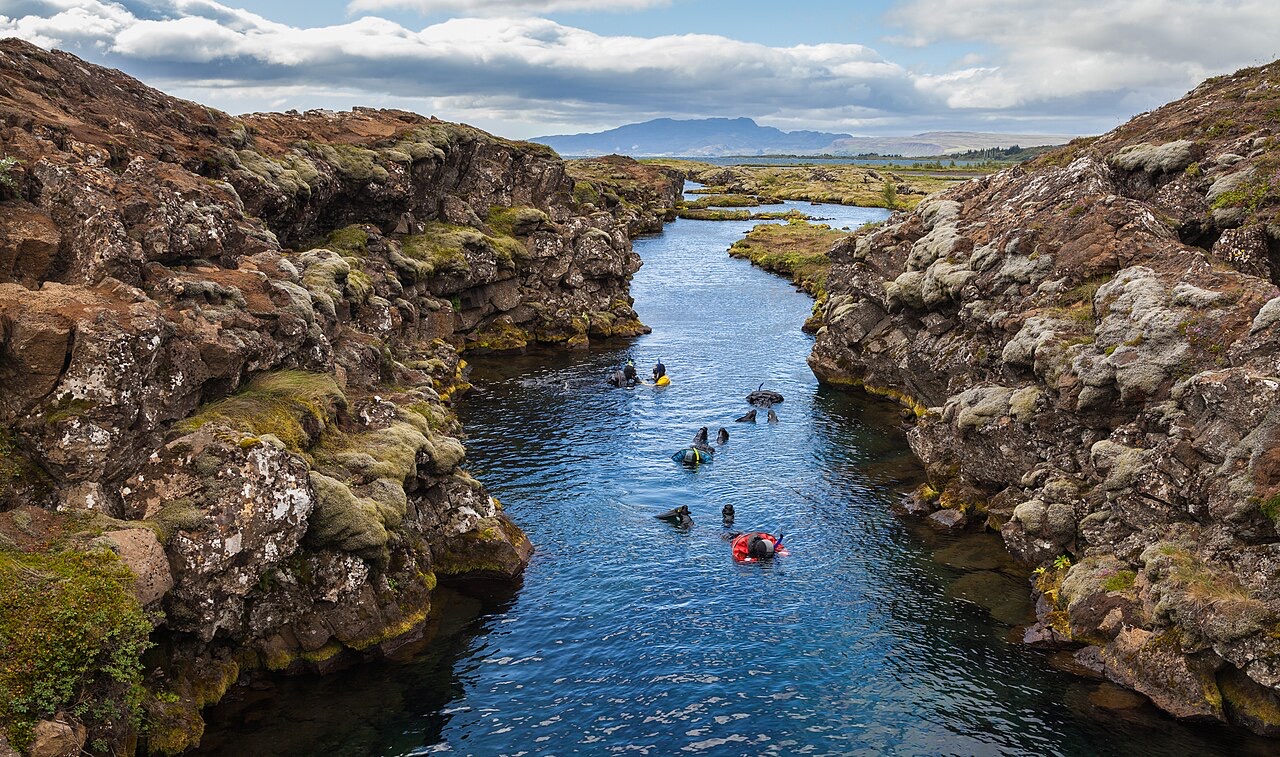
Snorkeling in the Silfra canyon , a rift between the tectonic plates (North American and Eurasian), Þingvellir National Park , Southern Region , Iceland .

Silfra Fissure

Freshwater 2–18 m Intermediate Silfra & Iceland, Iceland
Foto: Diego Delso · CC BY-SA 4.0
Terdokumentasi dengan baik
Kedalaman
2–18 m / 7–59 ft
Kedalaman tipikal
10 m / 33 ft
Visibilitas
70–100 m / 230–328 ft
Air
2–4 °C / 36–39 °F
Arus
Mild
Akses
Shore
Bulan-bulan terbaik
May–Sep
Sertifikasi yang disarankan
Open Water plus drysuit certification or documented drysuit experience
Dive tipikal
~35 min

Kedalaman adalah rentang dari bagian teratas lokasi hingga maksimum biasanya; "sertifikasi yang disarankan" adalah level agen arus utama yang biasanya diminta operator, bukan aturan hukum. Arus dan visibilitas berubah setiap hari, jadi anggap semua ini sebagai rentang perencanaan.

Silfra is the rare dive whose reputation undersells it. The fissure is a crack in the rift valley where the North American and Eurasian plates separate, flooded by glacial water that has spent decades filtering through lava before surfacing at 2–4 °C, clean enough to drink mid-dive. Visibility runs to the length of the site itself: in the Cathedral section the entire hundred-meter canyon hangs in view at once, blue over black basalt, with green algae streamers the only vegetation. The profile is shallow and the flow does the work; cold hands and camera settings are the only real challenges.

Momen yang Anda nantikan: Swimming a tectonic boundary, visibility beyond 80 m, drinkable glacier water, the Cathedral's blue perspective

Topografi: Basalt canyon walls and boulder floor through the sections Big Crack, Silfra Hall, Silfra Cathedral and Silfra Lagoon

Arus: A gentle constant flow pushes divers along the fissure toward the lagoon: navigation mostly takes care of itself.

Entri: Metal stairs at the entry and exit platforms inside Thingvellir National Park; all dives are guided and equipment is hauled from the nearby car park.

Ketahui sebelum kamu nyebur

Bahaya: Water at 2–4 °C: regulator free-flows, rapid hand numbing and short no-fuss dive times. Listen to the cold-water briefing.

Izin & aturan: Diving only through operators licensed by the park; drysuit prerequisite enforced; park fees apply.

Konservasi: A protected site inside a UNESCO World Heritage national park: no touching the walls, no disturbing the algae, nothing removed.

Untuk fotografer

Wide angle: ★★★★★ · Makro: ★☆☆☆☆ (penilaian 1–5 dari editor tentang apa yang ditawarkan lokasi ini untuk setiap gaya pemotretan)

Australia, Selandia Baru & Asia Timur

Cairns & the Ribbon ReefsNingaloo ReefCoral Sea & Osprey ReefOkinawa & the Kerama IslandsPoor Knights IslandsTownsville & the YongalaGreen IslandIzu Peninsula

Karibia & Atlantik Barat

BonaireCozumelRiviera Maya & the CenotesBelize Barrier ReefGrand CaymanIsla Mujeres & CancúnRoatánTiger Beach & Grand Bahama

Eropa, Atlantik & Mediterania

Malta & GozoSilfra & IcelandThe AzoresCanary IslandsLarnaca & the ZenobiaScapa FlowArctic NorwayMadeira

Samudra Hindia & Afrika Timur

North & South Malé AtollsAri AtollBaa Atoll & Hanifaru BayAliwal Shoal & UmkomaasMafia IslandMauritiusSeychellesSodwana Bay

Kepulauan Pasifik & Mikronesia

PalauChuuk (Truk) LagoonFakaravaKona, HawaiʻiRangiroaTaveuni & Rainbow ReefBeqa Lagoon & Pacific HarbourEspiritu Santo

Laut Merah & Timur Tengah

Sharm El Sheikh & Ras MohammedBrothers, Daedalus & St John'sDahabHurghada & El GounaMarsa Alam & the Deep SouthAqabaDaymaniyat IslandsMusandam Peninsula

Asia Tenggara & Segitiga Terumbu Karang

Bali & Nusa PenidaKomodoRaja AmpatSipadan & MabulAnilaoCoronKoh TaoLembeh Strait

Amerika & Pasifik Timur

Galápagos IslandsCocos IslandFlorida KeysSea of Cortez & Cabo PulmoSocorro & the RevillagigedosBritish ColumbiaCalifornia Channel IslandsCosta Rica Pacific Coast