Descubra onde mergulhar, quando ir e o que poderá ver.

Descubra onde mergulhar, quando ir e o que poderá ver.
★
Menu
Destinos Pontos de Mergulho Vida Marinha Naufrágios Notícias
Planejar uma viagem Planejador de viagem Quando mergulhar Calculadora de custos Comparações Calendário de vida marinha Temperatura da água Liveaboards Operadores & resorts Parques marinhos Câmaras hiperbáricas Mapa mundial
Mergulho em cavernas Todo o mergulho em cavernas Destinos e Pontos de Mergulho Sistemas de Cavernas e Mapas Formação e qualificações Centros de Mergulho e Guias Equipamento e Tecnologia Pesquisa de segurança e incidentes Ciência, história e conservação Recursos e atualizações
Regiões Austrália, Nova Zelândia e Ásia OrientalCaribe e Atlântico OcidentalEuropa, Atlântico & MediterrâneoOceano Índico e África OrientalIlhas do Pacífico & MicronésiaMar Vermelho & Médio OrienteSudeste Asiático e Triângulo de CoralAs Américas e o Pacífico Oriental Países
Aprender e Ferramentas Todos os guias Certificações Guias de equipamento Vídeos Consulte os Dados Agentes de IA API
Sobre Sobre nós Metodologia Aviso legal Contato
A sua vista
★ Guardado

Os seus destinos, pontos de mergulho e espécies favoritos, guardados neste browser.

API GATEWAY

Acesso JSON gratuito e só de leitura aos dados em cache do atlas.

Modo escuro

Vista Guiada
Novo no mergulho? Profundidades, correntes, níveis de certificação? Explicamos cada termo enquanto navegas, em linguagem simples. Os mesmos dados, com a ajuda incluída.

Vista de Especialista
Já sabe a diferença entre uma parede e um drift dive. Apenas os dados: limpos, rápidos e compactos. Esta é a vista predefinida.

Idioma da interface
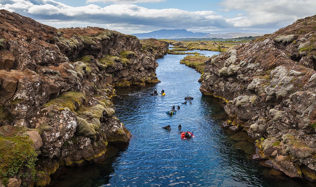
Snorkeling in the Silfra canyon , a rift between the tectonic plates (North American and Eurasian), Þingvellir National Park , Southern Region , Iceland .

Silfra Fissure

Freshwater 2–18 m Intermediate Silfra & Iceland, Iceland
Foto: Diego Delso · CC BY-SA 4.0
Bem documentado
Profundidade
2–18 m / 7–59 ft
Profundidade típica
10 m / 33 ft
Visibilidade
70–100 m / 230–328 ft
Água
2–4 °C / 36–39 °F
Corrente
Mild
Acesso
Shore
Melhores meses
May–Sep
Certificação recomendada
Open Water plus drysuit certification or documented drysuit experience
Mergulho típico
~35 min

A profundidade é o intervalo entre o topo do local e o seu máximo habitual; "certificação recomendada" é o nível das agências convencionais que os operadores normalmente exigem, não uma regra legal. As correntes e a visibilidade mudam diariamente, por isso trata tudo isto como intervalos de planeamento.

Silfra is the rare dive whose reputation undersells it. The fissure is a crack in the rift valley where the North American and Eurasian plates separate, flooded by glacial water that has spent decades filtering through lava before surfacing at 2–4 °C, clean enough to drink mid-dive. Visibility runs to the length of the site itself: in the Cathedral section the entire hundred-meter canyon hangs in view at once, blue over black basalt, with green algae streamers the only vegetation. The profile is shallow and the flow does the work; cold hands and camera settings are the only real challenges.

O momento pelo qual você vem: Swimming a tectonic boundary, visibility beyond 80 m, drinkable glacier water, the Cathedral's blue perspective

Topografia: Basalt canyon walls and boulder floor through the sections Big Crack, Silfra Hall, Silfra Cathedral and Silfra Lagoon

Corrente: A gentle constant flow pushes divers along the fissure toward the lagoon: navigation mostly takes care of itself.

Entrada: Metal stairs at the entry and exit platforms inside Thingvellir National Park; all dives are guided and equipment is hauled from the nearby car park.

Sabe antes de entrar na água

Perigos: Water at 2–4 °C: regulator free-flows, rapid hand numbing and short no-fuss dive times. Listen to the cold-water briefing.

Licenças & regras: Diving only through operators licensed by the park; drysuit prerequisite enforced; park fees apply.

Conservação: A protected site inside a UNESCO World Heritage national park: no touching the walls, no disturbing the algae, nothing removed.

Para fotógrafos

Grande angular: ★★★★★ · Macro: ★☆☆☆☆ (classificação de 1–5 dos editores sobre o que este sítio oferece a cada estilo de fotografia)

Austrália, Nova Zelândia e Ásia Oriental

Cairns & the Ribbon ReefsNingaloo ReefCoral Sea & Osprey ReefOkinawa & the Kerama IslandsPoor Knights IslandsTownsville & the YongalaGreen IslandIzu Peninsula

Caribe e Atlântico Ocidental

BonaireCozumelRiviera Maya & the CenotesBelize Barrier ReefGrand CaymanIsla Mujeres & CancúnRoatánTiger Beach & Grand Bahama

Europa, Atlântico & Mediterrâneo

Malta & GozoSilfra & IcelandThe AzoresCanary IslandsLarnaca & the ZenobiaScapa FlowArctic NorwayMadeira

Oceano Índico e África Oriental

North & South Malé AtollsAri AtollBaa Atoll & Hanifaru BayAliwal Shoal & UmkomaasMafia IslandMauritiusSeychellesSodwana Bay

Ilhas do Pacífico & Micronésia

PalauChuuk (Truk) LagoonFakaravaKona, HawaiʻiRangiroaTaveuni & Rainbow ReefBeqa Lagoon & Pacific HarbourEspiritu Santo

Mar Vermelho & Médio Oriente

Sharm El Sheikh & Ras MohammedBrothers, Daedalus & St John'sDahabHurghada & El GounaMarsa Alam & the Deep SouthAqabaDaymaniyat IslandsMusandam Peninsula

Sudeste Asiático e Triângulo de Coral

Bali & Nusa PenidaKomodoRaja AmpatSipadan & MabulAnilaoCoronKoh TaoLembeh Strait

As Américas e o Pacífico Oriental

Galápagos IslandsCocos IslandFlorida KeysSea of Cortez & Cabo PulmoSocorro & the RevillagigedosBritish ColumbiaCalifornia Channel IslandsCosta Rica Pacific Coast